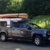

A few weeks ago my brother and I were wandering around the hundreds of miles of gravel roads in the Reserve Faunique La Verendrye in Quebec when I noticed something odd on the Earthmate map on my rig's iPad. I took a quick screen-cap of it....
(Click to enlarge)
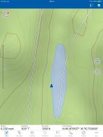
We had been following that road on the left but at this point our position-arrow decided to take a dip in the lake.
And best we could figure, that road through the lake must be an ice-road and we just happened to be there off-season and couldn't see it 

 .
.
Seriously, though, I was surprised to see Earthmate wasn't doing as well as expected given I had downloaded the Topo North America map of Quebec to it.
A bit of inaccurate background map isn't a big deal but we were in an area with lots of logging roads -- some mapped, some not-- and we had some problems determining which roads went where we wanted to go and which just ended at a logging pad. After a while we found ourselves unable to tell which road we were on (on the iPad) because our position was so inaccurately displayed.
Fortunately, we had a paper hunting map of the Reserve and we had a GPS with Canadian maps to help us figure it out. The Garmin (Montana) GPS actually did better than Earthmate in this area.
The paper hunting map showed hunting sectors and that info helped us read sector-boundary signs to confirm we were on the right road. In one case, for example, informal km markers appeared to show we had made a wrong turn. But the hunting-sector numbers confirmed we were on the road we wanted.
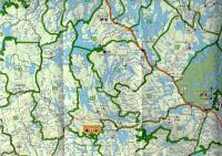
(post edited 9/6 to add paper map scan)
.
Edited by Old Crow, 06 September 2018 - 12:25 PM.