Jump to content


Photo
- - - - -

Death Valley Boondocking


  • Please log in to reply
11 replies to this topic

#1 BillTheHiker

BillTheHiker

    Senior Member

  • Members
  • 307 posts
  • LocationBoise, ID

Posted 01 November 2018 - 03:57 PM

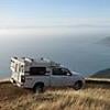
I am looking for boondock suggestions inside the park and at the lower elevations where it will be warmest in the winter. Last year I found I had to drive really long distances to find a camp from most trailheads  I  hiked at. I guess that's just the way the park is.


Heading out soon to spend the winter in the desert SW. Last year on my way South I spent end of November into early December in Death Valley.  Echo Canyon was the only place I found near Furnace Creek. Cottonwood Canyon near Stovepipe Wells has nice camping, but it can be an hour long, rough ride just to spend the night. There is the inexpensive "campground" in town but is just a dirt parking lot and some of the RVs were running noisy generators, so not to my taste.


The map I got from the Visitor center shows where boondocking is allowed and there were very few places. With all that real estate I was surprised the rules are so restrictive. Maybe there are other places that are not "official"?


  • 0

#2 SunMan

SunMan

    King Taco

  • Members
  • 2,362 posts
  • LocationOxnard, CA.

Posted 01 November 2018 - 04:32 PM

There are a numerous roads off of westside road that allow camping up on the alluvial fan, you just need to head two miles up.


Not sure what map you have but you should be able to camp off of most (not all) roads provided you are at least 2 miles back. No shortage of boondock locations in Death Valley. Good luck, tis the season.


  • 0

Sunman
2003 Four Wheel Camper -Hawk

2023 All Terrain Camper - Panther 
2006 Toyota Tundra Double Cab Limited 4WD
2017 Toyota Tundra Double Cab Limited 4WD


#3 BillTheHiker

BillTheHiker

    Senior Member

  • Members
  • 307 posts
  • LocationBoise, ID

Posted 01 November 2018 - 06:21 PM

SunMan,


Map was given out by rangers at the Visitor Center in Furnace Creek. A single, photocopy sheet showing the major roads with red lines marking areas where it is OK to camp. Between Furnace Creek and Stovepipe there is nothing. I hiked Marble Canyon and my only boondock options were up Cottonwood Canyon or Echo Canyon, both about an hour or so drive. 


I did three of the four old mining roads off Westside road last year and am looking for some new areas to explore.


  • 0

#4 SunMan

SunMan

    King Taco

  • Members
  • 2,362 posts
  • LocationOxnard, CA.

Posted 01 November 2018 - 07:42 PM

Cottonwood was probably your best bet from Marble. Or up Emigrant near Tucki Mine or Lemoigne.
 
Recommend getting a Benchmark map or similar and search out dirt roads, maybe you can plan your post hike camps using that method. Or a more detailed guide book like these can help:

https://www.amazon.c...ll death valley

https://www.amazon.c...s/dp/0965917800
  • 0

Sunman
2003 Four Wheel Camper -Hawk

2023 All Terrain Camper - Panther 
2006 Toyota Tundra Double Cab Limited 4WD
2017 Toyota Tundra Double Cab Limited 4WD


#5 ski3pin

ski3pin

    Belay On

  • Site Team
  • 15,336 posts
  • LocationSierra Nevada Range

Posted 01 November 2018 - 10:17 PM

The regulations for distance from main roads has changed to 1 mile (from 2). Cottonwood is still up to the mouth of the canyon, around 8 miles from Stovepipe. Hole in the Wall Road is easier than Echo Canyon with more sites. We have seen many people pull in Lemoigne at dusk and drive the required 1 mile in - but it helps to be familiar with that road and find the few flat spots available just off the road. Off the West Side Road - just opened yesterday - is Trail Canyon, Hannapah, Johnson, Galena, Butte Valley - drive a mile up to be legal. Also, please remember no campfires in the backcountry. As SunMan mentions, the road to Tucki Mine/ Telephone Canyon is just off of Emigrant Road.


  • 0

2003 Ford Ranger FX4 Level II 2013 ATC Bobcat SE "And in the end, it's not the years in your life that count. It's the life in your years."- Abraham Lincoln  http://ski3pin.blogspot.com/


#6 BillTheHiker

BillTheHiker

    Senior Member

  • Members
  • 307 posts
  • LocationBoise, ID

Posted 04 November 2018 - 05:52 PM

Last nite on my way South I found a good boondock site 20 miles S. Of Tonopah on signed road to Alkalai. 8 miles in is the abandoned processing operation where an FWV/ATC and 2 others camped. I chose a more wind protected gully nearby. Was visited be a horse and later 2 burros.

Will drive Phinney Canyon today and checkout ghost towns in the area, and should be able to find camp in there.
  • 0

#7 SunMan

SunMan

    King Taco

  • Members
  • 2,362 posts
  • LocationOxnard, CA.

Posted 05 November 2018 - 02:43 PM

Strozzi ranch is worth the drive as is the back way into Rhyolite.
  • 0

Sunman
2003 Four Wheel Camper -Hawk

2023 All Terrain Camper - Panther 
2006 Toyota Tundra Double Cab Limited 4WD
2017 Toyota Tundra Double Cab Limited 4WD


#8 BillTheHiker

BillTheHiker

    Senior Member

  • Members
  • 307 posts
  • LocationBoise, ID

Posted 06 November 2018 - 07:18 PM

On Sunday drove back road Rhyolite to Phinney canyon, but took the wrong road and ended up in the right place but after a gnarly downhill section that nearly rolled my rig. So I returned by taking Phinney Rd to US 95. Unlimited camping in that area.
  • 0

#9 BillTheHiker

BillTheHiker

    Senior Member

  • Members
  • 307 posts
  • LocationBoise, ID

Posted 07 November 2018 - 06:34 PM

There is a great boondocking off Daylight pass rd. 3 miles West of Titus Canyon turnoff is an unsigned road heading south. For 7 miles there are numerous flat spots on the playa right next to the road. Last 3 miles have many dips into runoff ditches. It then hits a T intersection that heads East 6 miles to US 95 south of Beatty, and that is an easier drive, also with lots of camping. I took the fork West to a junction with the Chloride Cliffs road to Chloride City, and that is one nasty, steep grade. Upon returning, I went East at the Chloride junction which goes to Daylight Pass road and this is the route described in guide books. BUT, it turned me back on the downhill section. I scouted this one blind turn on foot and decided I could not do it. Would love to hear from anyone that has taken their camper on that road. I drove the road out to US 95 and camped one night on that route. In those 2 days I saw 2 campers and one SUV headed to Chloride.
  • 0

#10 ski3pin

ski3pin

    Belay On

  • Site Team
  • 15,336 posts
  • LocationSierra Nevada Range

Posted 07 November 2018 - 09:17 PM

The road from Daylight Pass (also is the access for Monarch Canyon) road to the Chloride Cliff intersection? Yes, we drove it early this year.


  • 0

2003 Ford Ranger FX4 Level II 2013 ATC Bobcat SE "And in the end, it's not the years in your life that count. It's the life in your years."- Abraham Lincoln  http://ski3pin.blogspot.com/


0 user(s) are reading this topic

0 members, 0 guests, 0 anonymous users