
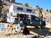
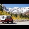
We've been having simply glorious weather here- 70s and sun- after a very wet spring. Sure sign of summer here- the camper is on the truck as of today. Better late than never I say. Heading out for the first trip this coming week.


Summertime!
Started by
MarkBC
, Jun 01 2019 04:37 PM
29 replies to this topic
#12

Wandering Sagebrush
-

- Site Team
- 10,572 posts
Free Range Human
- LocationNortheast Oregon
Posted 13 June 2019 - 12:48 AM
99.7° on our south facing deck, probably 95° away from there. Too blasted hot!
I am haunted by waters
#13
EM4
-

- Members
-

- 78 posts
Advanced Member
- LocationLas Vegas, originally Vancouver BC
Posted 13 June 2019 - 05:34 PM
86 at 530 am in Vegas. Looking at at least 105 today Thursday June 13. Summer started 2 weeks ago.around here
#14
Smokecreek1
-
- Members
- 2,761 posts
Smokecreek1
- LocationNE Calif/NW Nev
Posted 16 June 2019 - 08:41 PM
We are hitting the 90's for the first time this week in Susanville-that's to hot for yard work  so I'm heading up to the Devils Garden (Res C or F or Jane's ) on the Modoc Plateau mid week or so. Okay, I know the Valley and Vegas are hotter, so I'm a wimp-like it hot-but not to hot! I had thought about heading to the coast, but don't think I would make it across the valley; besides not up for a real long trip with the Sierra shindig coming up in July! Temps up on the Modoc are supposed to be in the low 80's, then drop into the low 70's, so it's worth another run up there after just getting back; res's were full and the fishing is good! Should not be many people up there now, might later also head over to Lakeview, Adel area, maybe Fields and points East. Anyone wanting to run away from the heat drop a line here or PM me!
Smoke
Edited by Smokecreek1, 16 June 2019 - 08:55 PM.
Smokecreek1:99F1504x4with05Granby
#15
Old Crow
-
- Members
- 1,059 posts
Searching....
- LocationSouth Central PA
Posted 18 June 2019 - 06:35 PM
I mentioned earlier in this thread I had spent the $10 for RadarScope for my iPad to learn more about summer storms. And in closing I said I'd also like to see lightning strikes.
After looking at several dedicated lightning-strike apps in the app store, I decided to instead upgrade my RadarScope to the Pro version. That's another $10 and it's a yearly subscription so it'll be another $10 each year if I want to continue seeing the Tier One add ons.
I figured the upgrade would mean I'd have to mess around with creating an account, figuring out what password to use and how to keep it safe, etc. But no, all I had to do was click on the tools gear in the app and tap on Pro to have it show my options for purchase. I tapped Pro Tier One and was prompted by Apple for the purchase. A Touch-ID later it was on my iPad.... similar to the initial app purchase.
The Pro Tier One version adds not only lightning strikes, but also gives me the option for a Dual-Pane display. There wasn't anything going on in my area but I could see something was up in the Cincinnati area so selected the nearest radar for that area...
(Click to enlarge)
(Note: I clicked on one of the storm tracks in the lower pane so you can see what the pop-up shows.)
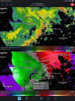
The top pane is Reflectivity, the bottom Velocity... uhh-- wait a minute-- I better let Pecos Hank take over from here.....
.
Edited by Old Crow, 18 June 2019 - 06:52 PM.
'01 FWC Hawk shell on a '13 Tundra Double-Cab + '19 Ford Transit van with Quigley 4x4 option
#16
Old Crow
-
- Members
- 1,059 posts
Searching....
- LocationSouth Central PA
Posted 23 June 2019 - 01:16 PM
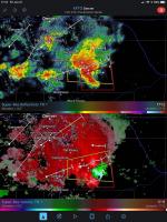
RadarScope view of a summertime storm southeast of Denver Friday evening....
The app has a little red oval with a number in its upper right corner. When I click on it, up pops a list of current tornado watches (in red), severe thunderstorm watches (in yellow) and flood watches (in green). Clicking on any of the watches changes the view to the applicable radar. The new view shows the outline of the watch area on the (zoomable and pan-able) map.
On Friday, I saw there were tornado and severe thunderstorm watches southeast of Denver in Elbert county. The display showed me some features I like....
(Click to Enlarge)
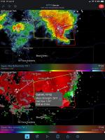
At the start of the track we see a circle with little arrows... indicating the spinning air of a mesocyclone has been picked up on radar. And when I clicked on it in the Velocity pane we see a Meso Strength score (this a moderate score) and hail size.
As I kept checking I sometimes saw a tornado icon (instead of the mesocyclone icon), indicating a tightening of the spinning in what's called a Tornado Vortex Signature.
(Click to Enlarge)
I don't believe there were sightings of a tornado in the area but I did find this storm-chaser video of hail there in Elbert County on Friday...
https://youtu.be/htWT9JiOAZU?t=84
PS-
The explanations of the icons (the 'attributes') are on this Weather Ops blog page and include hail (double circle), mesocyclone (circle with arrows), Tornado Vortex Signature (tornado symbol). The Meso Strength scale is also explained (<2300=weak, 2300-3600=moderate, >3600=strong)
PPS- I noticed the announcement for the latest version of RadarScope says they've added support for another category-- snow-squall warnings (<1/4 mile visibility, freezing ground temps, duration < 1 hour, dangerous or life-threatening conditions). Also- more Canadian radars.
.
Edited by Old Crow, 24 June 2019 - 11:41 AM.
'01 FWC Hawk shell on a '13 Tundra Double-Cab + '19 Ford Transit van with Quigley 4x4 option
#17
MarkBC
-
- Site Team
- 6,599 posts
The Weatherman
- LocationBend, Oregon
Posted 02 July 2019 - 01:15 AM
This is the third p.m. in a row here with Flash BOOM!... Splash.
Thunderstorms are not particularly rare in central Oregon...but we're not like all those states east of the Rockies. Three days in a row is a bit unusual.
Having showers with the FLASH (it's pouring right now) is a good thing from a fire standpoint.
FWC Hawk (2005) on a Ford F250 Supercab, 6.8L V10 gas (2000)
#18
ski3pin
-

- Site Team
- 15,315 posts
Belay On
- LocationSierra Nevada Range
Posted 02 July 2019 - 01:53 AM
Enjoy it while you can!
2003 Ford Ranger FX4 Level II 2013 ATC Bobcat SE "And in the end, it's not the years in your life that count. It's the life in your years."- Abraham Lincoln http://ski3pin.blogspot.com/
#19
MarkBC
-
- Site Team
- 6,599 posts
The Weatherman
- LocationBend, Oregon
Posted 02 July 2019 - 07:11 PM
FWC Hawk (2005) on a Ford F250 Supercab, 6.8L V10 gas (2000)
#20
pvstoy
-
- Members
- 2,768 posts
Senior Member
- LocationCarson City, NV
Posted 03 July 2019 - 12:03 AM
What is the path? Going west?
Patrick
2015 FWC Hawk Flatbed


0 user(s) are reading this topic
0 members, 0 guests, 0 anonymous users

