

‘Quick Report’ 3-1 to 3-14. We had to enter the WRT through the Potash Rd on 3-1 for our five nights of camp reservations; Gooseberry [3-1], White Crack [2 nights], Murphy and Taylor. From 1900 to 0400 at Gooseberry we had a hard downpour. Then no more rain on WRT. Biggest surprise on WRT were the two major climbs; Murphy Hogback [almost stalled out at the cruz location half way up; tires spinning on solid rock shelf] and Hardscrabble. They were tough [20%] with blue sky only view out windshield but what made them nerve wracking was the potential of meeting someone coming the opposite direction on either grade. Up-hill right of way means nothing, since neither vehicle could back up or down. We only encountered three vehicle on WRT and one was going CCW while we and the rest were CW. This must be stopped or someone is going to bite it. Simple to only issue permits for a CW direction [recommended direction by BC Rangers]. The WRT was drop-dead gorgeous but understand that it is a crawl; we averaged about 4 mph for the 90+ miles.
Moab was a zoo with a total tourist trap feel [I grew up in Reno]; Razor/Jeep rentals ruled. Nice local folks and aquatic center has great showers. Maverick gas stations [either end of town] have potty dumps and potable water sources.
2-28 overnight at Fisher Towers; highly recommend and easy to get to.
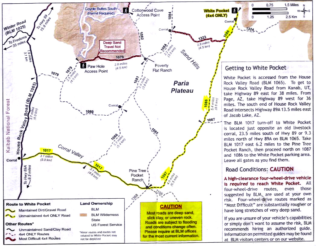
Other stops and routes but memorable ones were Muley Point overnight, outstanding panoramas and 2 Vermillion Cliffs sites. State Line CG on Rock House Road was an A+. Permit for S. Coyote on 3-11; got there 3-10 and had another heavy downpour overnight. 4+ hours on 3-11 photographing and then went to White Pocket via 1084 at Poverty Flats ‘Ranch’ to 1086 to White Pocket. I do not recommend this route to White Pocket; in-spite of wet sand, better traction, the sand was bottomless and deeply rutted. The last downhill grade before 1086 was extremely deep and loose; I doubt I could have gotten back up it. My wife had taken a photo tour to both before and we agreed that White Pocket is #1; plus for now no permits.
We left White Pocket on 3-13 with rain in forecast and drove out on 1086-1087 the only way to go in or out in my opinion. Still rock ledges and deep sand but 100% better than 1084.
Our Tuweep CG reservations were for 3-14 and 3-15 but the night of 3-13 in Kanab we had a biblical rain [with snow in AM] fall all night into 3-14. Tuweep was out; coupled with more rain and snow coming and possibility of the insane potential for travel restrictions between states we cut for home. Leaving Tuweep on the table, cancelling Hell's Backbone Grill dinner [that was tough to do]; cutting out HITR and Cathedral Valley [which we had previously camped at].
WRT and White Pocket were the gems. Worth the effort to get to them; BUT I am done with crazy lottery, permit crap. Back to locations without people; they do exist!
Phil
Edited by Wallowa, 17 March 2020 - 05:31 PM.


