I might have you beat on this one, dorocks! As soon as I can, which will likely be no sooner than a couple of weeks, I'll post a TR and some pics, but for now I'll just say:
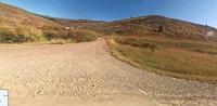
For the second trip in a row I nosed my truck and popup camper trailer, around 41' nose to tail and around 13,000 lbs on the hoof, into a road (actually a trail this time) where I did not know what the current conditions were, nor did I have decent topo maps. Like in 2015, I THOUGHT I'd learned enough about the route before taking it, but clearly I had not. To make it worse, this time I went in with the full understanding that my low range was not working, nor was the shift selector allowing me to hold it in Low (1st) gear. The result was several descents which were absurdly steep shelf segments and the need to stop several times on each to cool the brakes.
As if that was not bad enough, I managed to knock the trailer off of the hitch in the dry wash at the bottom of an absurdly steep descent about halfway through the knarly section of trail, which was only around 6 miles in total distance (out of around 35 miles total length), but with ascents/descents in a roller-coaster fashion with a couple of knife-edge pitches just wide enough for the two-track trail thrown in for good measure. It took an hour in the 100 degree furnace of the dry wash for me to get the trailer properly chocked, the big floor jack out and set up, jacking the coupling up enough to get it ball under it, and get the whole thing reconnected and the tools stowed. Then we had to tackle the ascent from the bottom of the dry wash back up to the top of the plateau.
So that was, overall, a 600' ascent, but completed by picking it up and losing much of it in several 100-200' and absurdly steep sections (the aforementioned roller-coaster). And completed on a 100 degree F afternoon with very little airflow through the radiator which also houses the OEM transmission cooler, and without low range. And that combination of factors caused my transmission temp to spike for the first time in 16.5 years of owning the truck--spiked all the way up to the top of the yellow and was the width of the needle from the red. So I had to stop on the ASCENTS to let the transmission cool down. The old running joke on the OEM trans temp gauges on the '02 era Superduty 4R100 transmissions is that the gauge tells you the precise moment at which you've cooked your transmission, so I was plenty worried about that in addition to the specter of smoking the brakes to the point of failure.
We could see the highway bridge over the Missouri River (US 191 north of Lewistown) at the end of the trail from several vantage points after we got back on top of the edge of the plateau so we knew we were making progress, and even my less than ideal maps told me the same thing. But when we reached a point around a half-mile from the highway and could see it line-of-sight, a large orange road construction sign appeared to have been placed directly in the middle of the road (ie appeared to block it), right where a small ravine crossed it just 300' from the pavement. I told my wife to try to relax, but there may be a bridge or culvert out before the road and we might have to go all the way back through the dry wash and out the way we came in. Fortunately, the sign was actually right on the edge of the road and it advised of construction on the paved highway.
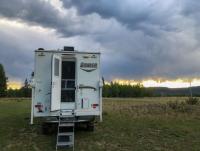
After unlocking the hubs, checking the coupling and all related items (especially the chains!) carefully, and accelerating smoothly up to cruising speed, I gently suggested a motel and dinner out rather than the next 130 miles of graded gravel roads with a primitive campsite at the end of it, a pitch we'd planned on covering that afternoon. Suggestion met with approval, we drove to Glasgow and got a nice motel room. After she nodded off, I went back online to check the route description I'd read months before and hadn't re-read before committing to the route: "Very difficult climb out of Two Calf Creek", "only one of the BLM Backcountry Byways I've driven where 4WD and Low Range are required", and my personal favorite " Trailers: NO". I decided not to tell my wife about any of that.
For the benefit of any planning any trips to the area, the trail is the Missouri Breaks Backcountry Byway and the western end, towards Winifred, MT is under the BLM. Land management changes from BLM on the west to US FIsh and Wildlife Svc just west of the descent into Two Calf Creek (USFWS Road 307 connecting to Road 209 on the east side, at the top of the plateau and remaining 209 all the way to US 191 at the James Kipp Rec Area on the Missouri River at 191). The BLM end is well maintained; the USFWS not so much. Had there been even a hint of moisture on the USFWS end, our truck and trailer would still be there--all unimproved clay surface without a hint of gravel, and deeply incised with runoff ruts.
The knarly part of our drive that day was only 6 miles but it took 3 hours to complete it. That's right, it was a "three hour tour". Thank goodness Mary Ann is a patient and forgiving soul!
Gilligan