Jump to content


Photo
- - - - -

Navigation and Avenza Maps


  • Please log in to reply
11 replies to this topic

#11 AWG_Pics

AWG_Pics

    Into the Great Empty

  • Members
  • 1,194 posts
  • LocationOregon

Posted 03 September 2020 - 01:04 AM

I guess I am more old school than I thought. For my needs a garmin nuvi to get me into the general area, a gazetteer (Delorme or Benchmark), a compass for backup and maybe a geology guidebook or two are all I ever use, except for eyes and the feel of the road or trail. Generally I try not to be too dependent on GPS unless I am in a city -- where it is very useful. Different experience and expectations I suppose. 


So to answer the OP's first question. GPS will get you into the area -- then it is up to you after that.


Don't get me wrong -- I love maps. A big part of my early professional life was making maps of various types. I have all sorts of maps squirreled away all over in the house and the truck. But there is a time to get eyes off the screen and onto the terrain, in my opinion, anyway.


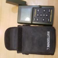
Here is my first GPS unit:


Attached Thumbnails

  • 20200902_180856.jpg

Edited by AWG_Pics, 03 September 2020 - 01:12 AM.

  • 0

lived for several years each in Montana, Utah, Idaho, Texas, Washington, Oregon.

2019 Tundra, Hawk.

https://www.flickr.c...hotos/awg_pics/


#12 Mthomas

Mthomas

    Senior Member

  • Members
  • 137 posts
  • LocationNorth Tahoe

Posted 07 September 2020 - 05:49 AM

Gaia is a solid app, but the map sources on it can be dated. Specifically, the USGS says it is 2016, but I have found many errors, old data issues. I think you need to have multiple resources available. Avenza, GaiaGPS, cal topo here in the west, and the Garmin maps. Google maps is still my go to when looking at satellite images for dispersed sites.


  • 0

2018 Hawk FD 2016 Ram 2500 6.7 CTD


0 user(s) are reading this topic

0 members, 0 guests, 0 anonymous users