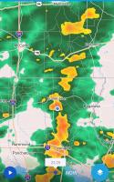
I'm camped at the blue dot shown on the radar map.

The Weatherman

Posted 04 December 2020 - 04:32 AM
FWC Hawk (2005) on a Ford F250 Supercab, 6.8L V10 gas (2000)
The Weatherman
Posted 24 December 2020 - 01:45 AM
I'm still in a region that isn't very wintery, so I won't talk about the temperature.
But take a look at the abrupt shift in wind direction - and magnitude - that's forecast to happen here tonight! 
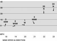
Those numbers across the bottom are hours,i.e., 6 - 11pm.
I'm camped on a south-facing shore -- just 50 feet from the water, so at least the strong north wind won't be blowing the briny wet onto shore and me.
FWC Hawk (2005) on a Ford F250 Supercab, 6.8L V10 gas (2000)
Belay On

Posted 25 December 2020 - 09:53 PM
a xmas gift...........................
Winter Storm Warning
URGENT - WINTER WEATHER MESSAGE
National Weather Service Sacramento CA
1200 PM PST Fri Dec 25 2020

...Impactful Winter Storm Expected for the Holiday Weekend...

.A winter storm will bring impactful winter weather across
interior northern California today into Saturday. Mountain snow
is expected across the Coast Range, the southern Cascades, western
Plumas County and the northern Sierra with this storm. Snow levels
will become lower tonight into Saturday morning. If traveling in
the mountains, carry chains, extra warm clothing and food, and be
prepared for significant travel delays.

CAZ068-069-261400-
/O.EXT.KSTO.WS.W.0009.201226T0000Z-201226T2100Z/
Western Plumas County/Lassen Park-
West Slope Northern Sierra Nevada-
1200 PM PST Fri Dec 25 2020

...WINTER STORM WARNING NOW IN EFFECT FROM 4 PM THIS AFTERNOON TO
1 PM PST SATURDAY ABOVE 4500 FEET...

* WHAT...Snow expected. Plan on difficult travel conditions.
  Total snow accumulations of 4 to 7 inches, with localized
  amounts up to 16 inches, are expected.

* WHERE...Western Plumas County/Lassen Park and West Slope
  Northern Sierra Nevada.

* WHEN...4 PM today to 1 PM Saturday.

* ADDITIONAL DETAILS...Be prepared for significant reductions in
  visibility at times. Local snow accumulations down to around
  4000 feet with be possible.

PRECAUTIONARY/PREPAREDNESS ACTIONS...

A Winter Storm Warning for snow means there will be snow covered
roads and limited visibilities. Travel is not recommended while
the warning is in effect. If you must travel, keep an extra
flashlight, food and water in your vehicle in case of an
emergency.The latest road conditions for the state you are
calling from can be obtained by calling 5 1 1.
2003 Ford Ranger FX4 Level II 2013 ATC Bobcat SE "And in the end, it's not the years in your life that count. It's the life in your years."- Abraham Lincoln http://ski3pin.blogspot.com/
Free Range Human

Posted 25 December 2020 - 10:51 PM
It’s snowing here now. Forecast is snow for the next 7 of 10 days. Staying home is an option.
first of what I expect to be several weather
One product issued by NWS for: 9 Miles ESE Baker City OR
URGENT - WINTER WEATHER MESSAGE
National Weather Service Boise ID
234 PM MST Fri Dec 25 2020
IDZ011-013-033-ORZ062-261215-
/O.CON.KBOI.WW.Y.0016.201226T0000Z-201227T0000Z/
West Central Mountains-Boise Mountains-Upper Weiser River-
Baker County-
234 PM MST Fri Dec 25 2020 /134 PM PST Fri Dec 25 2020/
...WINTER WEATHER ADVISORY REMAINS IN EFFECT FROM 5 PM MST /4 PM
PST/ THIS AFTERNOON TO 5 PM MST /4 PM PST/ SATURDAY...
* WHAT...Snow expected. Total snow accumulations of 3 to 6 inches
over the mountains, with up to 12 inches over the highest peaks.
* WHERE...Portions of northeast Oregon and west central Idaho.
* WHEN...From 5 PM MST /4 PM PST/ this afternoon to 5 PM MST /4
PM PST/ Saturday.
* IMPACTS...Plan on slippery road conditions.
PRECAUTIONARY/PREPAREDNESS ACTIONS...
Slow down and use caution while traveling.
The latest road conditions can be obtained by calling 5 1 1.
I am haunted by waters
Senior Member
Posted 26 December 2020 - 12:47 AM
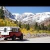
Rain shadow here on the back side of the Sierra.
Picture out front door at 3:10 light drizzle and full rainbow.
.
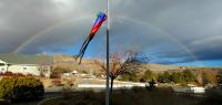
Patrick
2015 FWC Hawk Flatbed
C'est la vie
Posted 26 December 2020 - 05:13 PM
Nice Patrick.Did you search for the pots of gold at the end.
You have two to choose from.
Have a great day.
Frank
2002 Tundra AC TRD 4WD Limited 2009 ATC Bobcat loaded http://sharychic.blogspot.com/
Smokecreek1
Posted 26 December 2020 - 07:56 PM
Here in ne calif, weather seems to bounce from clear and way colder than usual to above ave. temps, with periods of rain, rain snow mix ,then snow, then repeat  ! The sky cleared the other night and I got to see the big astronomical event in the nw sky-now that was neat! Had a dust of snow this AM, now the sun is out, might be able to take "Timber Dog" for a walk later! Hope next year is a better one!
Smoke
Belay On
Posted 26 December 2020 - 09:11 PM
There is nothing like ice. This reminds me of our morning walk about a week ago. 
2003 Ford Ranger FX4 Level II 2013 ATC Bobcat SE "And in the end, it's not the years in your life that count. It's the life in your years."- Abraham Lincoln http://ski3pin.blogspot.com/
C'est la vie
Posted 26 December 2020 - 10:31 PM
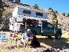
You have to be creative to work for UPS.
Why didn't he just walk up the snow.
Frank
2002 Tundra AC TRD 4WD Limited 2009 ATC Bobcat loaded http://sharychic.blogspot.com/
Free Range Human
Posted 26 December 2020 - 11:28 PM
Revenge is a dish best served cold... icy cold.
I am haunted by waters


0 members, 0 guests, 0 anonymous users

