Next episode
Soldier Meadows to High Rock Canyon
We drove north along the Soldier Meadows Road as a dust storm began to fill the playa with dust.
We had been warned about crossing the playa further north at Wheeler Reservoir where the water crossing was described as "three feet deep".
Another option we had discussed was following the Applegate Trail along the eastern boundary of the BR playa. Looking at the dust blowing from the SW towards that edge, we were glad we were on the western side of things.
Borrow pits were spaced every mile or two. I assume they have often needed to fill in washouts. Once in a while there was a side road to a ranch. What a spartan life it must have been out in the great beyond.

We got to Mud Meadow Reservoir where the Applegate trail joins the main road hearing north. Suddenly we were in Soldier Meadows and passed the cutoff to High Rock Lake. I put the RAM in reverse and drove backwards using my new rear camera. The OEM camera is on the tailgate, so this add on is attached just below the camper door. It plugs right in and I have the upgraded factory 8" monitor, thanks to Ramblin Chet's advice here on WTW.
I had spent some time on Google Earth, cross referencing with CalTopo scanned topo maps locating a few more springs I wanted to check out. We found two new spots, including one with a swimming pool ladder.

There must have been some carrion in the brush. As we drove out to the main trail a golden eagle, some ravens and another large raptor all flew up. By the time I got my camera out of the backseat they were mostly gone.

I also hiked back to some very hot sources, feeding streams, while SR kept Callie safe. Dogs and hot water are a bad combination. Later we went up a hill to a concrete picnic table with a trail to a hot pool that would fit a dozen people. I don't think that's a secret to anyone who goes to visit Soldier Meadows.
The winds were blowing hard as we walked back from our last soak, drying us immediately. I joked that the rocks on the concrete picnic table were to keep it from blowing away. I had pointed the truck into the wind, and we could barely pull the doors open. A storm was approaching, and a phalanx of clouds was moving in.
We continued up toward High Rock Lake, passing a yellow jeep at the Fly Canyon access. Later we talked to the gentleman, and he recommended the hike into the canyon to see large erosion pockets. His jeep had been left with all the windows wide open in the high winds. Later we saw he had a small dog, so maybe he left his dog behind for the hike.
We've visited the cabins at High Rock Lake before, so we pressed onward to the entrance of High Rock Canyon. BLM has designated four dispersed campsites within the traverse of the wilderness.
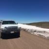
For travelers who want to run this trail, I don't recommend wet conditions, as the mud is very gooey like many volcanic soils.
IMPORTANT :
High Rock Canyon Road is closed each year between the end of chukar hunting season (around February 1st) until the second weekend in May to minimize human disturbance on nesting raptors and lambing bighorn sheep.
The road was quite brushy and there are some mandatory water crossings. There are long narrow stretches for only one vehicle width. Fortunately we had one other traveler going the same direction, the guy in the yellow jeep. My new truck got some pinstripes, or as some have suggested, I broke it in.
Scenery was stunning. This is not the brushy section.

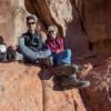
We had seen a cave shown on the map, and stopped to take a peek. It looks like there's been fires inside for thousands of years.

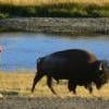
I had thought we might go as far as Pole Camp, where Pole Canyon and High Rock Canyon converge, but the wind had roughed up my eyes and I was ready for a break. I suggested we turn off to check out Conlon Camp and SR readily agreed. We were greeted by a bunch of cattle. The first we had seen in the area.

Getting into camp a bit early gave us time to fire up the Zodi and get some hot showers.

We could smell the rain coming, and then a rainbow burst into view.
I can't tell you the joy rain brings us parched Californians!


FYI: The notch in the canyon to the left of the truck is the first section of HRC we had just traversed.
Later in bed we enjoyed listening to the rattle of raindrops on our roof. I had stashed our chairs under the truck, and it rained much of the night.
Next episode:
High Rock Canyon to Steven's Camp and beyond