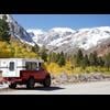
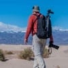
We will do the annual switch to snow tires on the Lady's Subaru tomorrow. 
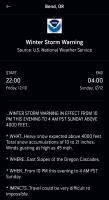
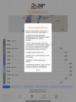
Winter Storm Watch
URGENT - WINTER WEATHER MESSAGE
National Weather Service Sacramento CA
300 AM PST Fri Dec 10 2021
...Winter Storm to Bring Heavy Snow to the Mountains...
.A strong winter storm will bring heavy snow to the mountains of
northern California. Snow will first arrive to northwestern
Shasta County Saturday afternoon, spreading southeast into the
southern Cascades and northern Sierra Saturday night or Sunday
morning. Snow levels will gradually lower over time through late
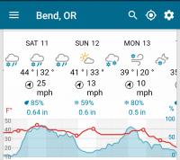
Monday and Tuesday. Expect major snowfall above 4000 feet with
several feet or more of snow. Anticipate significant travel delays
with extremely difficult to impossible travel over the mountains.
Strong winds will further reduce visibilities during this event
with white-out conditions.
CAZ014-068-069-110000-
/O.CON.KSTO.WS.A.0010.211212T0600Z-211215T0600Z/
Burney Basin / Eastern Shasta County-
Western Plumas County/Lassen Park-
West Slope Northern Sierra Nevada-
Including the city of Burney
300 AM PST Fri Dec 10 2021
...WINTER STORM WATCH REMAINS IN EFFECT FROM SATURDAY EVENING
THROUGH TUESDAY EVENING...
* WHAT...Heavy snow possible. Travel will be very difficult to
impossible. Damage to trees and power lines is possible. Total
snow accumulations of 2 to 4 feet above 4000 feet, with local
accumulations over 6 feet at the higher elevations, are
possible.
* WHERE...Burney Basin / Eastern Shasta County, Western Plumas
County/Lassen Park and West Slope Northern Sierra Nevada.
* WHEN...From Saturday evening through Tuesday evening.
* ADDITIONAL DETAILS...Significant reductions in visibility are
possible.
PRECAUTIONARY/PREPAREDNESS ACTIONS...
A Winter Storm Watch means there is potential for significant
snow, sleet or ice accumulations that may impact travel. Continue
to monitor the latest forecasts.


 !!!
!!!