Jump to content


Photo
- - - - -

Nevada Calls


  • Please log in to reply
42 replies to this topic

#21 Foy

Foy

    Resident Geologist

  • Members
  • 1,295 posts
  • LocationRaleigh, NC

Posted 07 May 2022 - 10:13 AM

Again, nice find, and many thanks for linking the modern geologic map of the two quadrangles. The work of R. B. Morrison published as USGS Professional Paper 401 in 1964 is impressive, and the work of Bell, Caskey, and House linked above expands very nicely on Morrison's.  


Their description of the "Ts" stratigraphic unit shows it to be a mixing bowl of sedimentary and volcanic derived sedimentary rocks, generally of rhyolitic composition but including some basaltic flows and tuffs (and the "intermediate" composition guessed by me initially falls between rhyolitic and basaltic.)  Notable in their description of the Ts unit is that the unit is locally highly silicified and Liesegang banded.  Silicification and Liesegang banding are post depositional processes generally related to hot silica rich fluids being introduced into the permeable sediments (silicification) and poorly understood geochemical process producing concentric banding (Liesegang banding--known as wonderstone).  Notably, the text description of Ts mentions formation of resistant peaks and ridges where silicification and alteration of Ts is prevalent, so my guess is that your  "green mountain" is one such sllicified zone within the Ts stratigraphic horizon.  I would further guess that locating and prospecting mapped exposures of Ts could be good wonderstone finding territory.  I don't have the impression that wonderstone is either rare or valuable, but I mention prospecting for samples cautiously because of having a zero percent understanding of the legal and ethical aspects of sample collecting within BLM lands.


Again, nice find!


Foy


  • 1

#22 searching for nowhere

searching for nowhere

    Senior Member

  • Members
  • 257 posts
  • LocationWestern Washington

Posted 07 May 2022 - 02:21 PM

Thanks.  I think I'm generally understanding the rock now. 


For everyone's info, below is a link describing what collecting is allowed on BLM land in Nevada.  Basically, one can collect small amounts of most anything for personal use/enjoyment.  There are some restrictions that are listed in the pamphlet.  


collecting_on_publiclands.pdf (blm.gov)


  • 0

Camping with a small trailer.  Everyday is a good day to go camping.


https://searchingfor.wordpress.com/


#23 Taku

Taku

    Buffalo Rockface

  • Members
  • 757 posts

Posted 07 May 2022 - 03:00 PM

the rocks at "Green Mountain" might be what Frank DeCourten refers to as "greenstones" on page 104 of his book The Broken Land


  • 1

2005 Tundra  2013 Ocelot    "Ridiculously comfortable"


2021 Tundra 2022 Cougar Shell Built Out  "Even more ridiculously comfortable"


#24 AWG_Pics

AWG_Pics

    Into the Great Empty

  • Members
  • 1,197 posts
  • LocationOregon

Posted 07 May 2022 - 03:05 PM


 I've circled the "mountain" with a blue circle and included a link to the geology map and text.  I'm 99% sure the location is correct because I used my InReach to locate it.  I find it interesting that there is no specific mention of it (that I understand) in the text when it is very prominent in the landscape.  I brought some rock home.  In looking at them I see small (1/64th") rounded white specs.  I don't see any grains in the green that would make me think of something like a sandstone.  Keep in mind I'm not a geologist, I'm just fascinated by geology.  


Geologic map of the Lahontan Mountains quadrangle, Churchill County, Nevada (second edition) [MAP AND TEXT] (unr.edu)


Here are some simple tests you can do in a minute or two: First heft the rock in your hand, does it feel lighter or heavier than say a similar chunk of granite? If lighter, look to see if there are air pockets in the rock (they are called vugs by geologists). If the rock is heavy with no air pockets, then you may have a chunk of olivine basalt. If the rock feels about the same or a bit lighter than granite, and has no air pockets, then you likely have a welded basaltic ash, probably of Tertiary age. If it is very light, then you may have a pumice. All these rocks are volcanic and likely yours is a volcanic ash, with some white feldspar crystals embedded. Can you take a picture of the rock and share it? 


Tony


  • 1

lived for several years each in Montana, Utah, Idaho, Texas, Washington, Oregon.

2019 Tundra, Hawk.

https://www.flickr.c...hotos/awg_pics/


#25 AWG_Pics

AWG_Pics

    Into the Great Empty

  • Members
  • 1,197 posts
  • LocationOregon

Posted 07 May 2022 - 03:24 PM

the rocks at "Green Mountain" might be what Frank DeCourten refers to as "greenstones" on page 104 of his book The Broken Land


Thanks Taku -- I just ordered a used copy of Frank's The Broken Land.


  • 0

lived for several years each in Montana, Utah, Idaho, Texas, Washington, Oregon.

2019 Tundra, Hawk.

https://www.flickr.c...hotos/awg_pics/


#26 Taku

Taku

    Buffalo Rockface

  • Members
  • 757 posts

Posted 07 May 2022 - 05:41 PM

you bet - an old friend who is a geology prof recommended it. I am looking forward to using it a lot in the near future since I retire on June 30th and can start to have more time


  • 0

2005 Tundra  2013 Ocelot    "Ridiculously comfortable"


2021 Tundra 2022 Cougar Shell Built Out  "Even more ridiculously comfortable"


#27 searching for nowhere

searching for nowhere

    Senior Member

  • Members
  • 257 posts
  • LocationWestern Washington

Posted 07 May 2022 - 06:42 PM

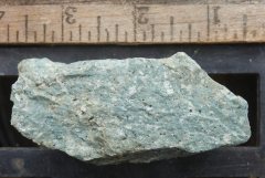
Foy:  You were smart to ask for a picture of the stone.  I didn’t describe it correctly.  Today with more light I see it differently.  It has more light spots and it has a few black flecks.  I got out a hand lens and verified that they are black specks, not small cavities.  The stone is lighter in weight than granite.  And it looks like a few air pockets.  

Below is a picture of the rock.  I think Wander the West reduced the file size and therefore reduced the quality.  I’ve added the original file to my blog.  


Taku:  I'm guessing it isn't the metamorphosed greenstone referred to in The Broken Land (yup, I have the book) because of Foy's comment on weight.


Grimes Point Area | searching for the middle of nowhere


May 07 2022 11

  • 0

Camping with a small trailer.  Everyday is a good day to go camping.


https://searchingfor.wordpress.com/


#28 AWG_Pics

AWG_Pics

    Into the Great Empty

  • Members
  • 1,197 posts
  • LocationOregon

Posted 07 May 2022 - 10:03 PM

Foy:  You were smart to ask for a picture of the stone.  I didn’t describe it correctly.  Today with more light I see it differently.  It has more light spots and it has a few black flecks.  I got out a hand lens and verified that they are black specks, not small cavities.  The stone is lighter in weight than granite.  And it looks like a few air pockets.  

Below is a picture of the rock.  I think Wander the West reduced the file size and therefore reduced the quality.  I’ve added the original file to my blog.  


Taku:  I'm guessing it isn't the metamorphosed greenstone referred to in The Broken Land (yup, I have the book) because of Foy's comment on weight.


Grimes Point Area | searching for the middle of nowhere


 It's Tony, not Foy, but that rock looks a lot like a chunk of welded ash flow that came out of a nearby volcanic vent as a hot, sticky, somewhat gassy dense cloud/flow. As it cooled and hardened a few bubbles were trapped. I imagine that under a handlens or an stereo microscope you would see much of the rock is made up of shards of glass-like fragments all solidified together. Interesting find. There are similar rocks around the cascade volcanoes. I have seen such on the Hummocks Trail near Coldwater Lake by Mt. St. Helens.


Oh, the green color? Volcanic ash deposits can come in almost any color due to trace minerals. Like the Painted Hills in central Oregon.


Edited by AWG_Pics, 07 May 2022 - 10:11 PM.

  • 1

lived for several years each in Montana, Utah, Idaho, Texas, Washington, Oregon.

2019 Tundra, Hawk.

https://www.flickr.c...hotos/awg_pics/


#29 searching for nowhere

searching for nowhere

    Senior Member

  • Members
  • 257 posts
  • LocationWestern Washington

Posted 07 May 2022 - 10:30 PM

Opps.  Sorry Tony.  And thanks for your comments.  


  • 0

Camping with a small trailer.  Everyday is a good day to go camping.


https://searchingfor.wordpress.com/


#30 Foy

Foy

    Resident Geologist

  • Members
  • 1,295 posts
  • LocationRaleigh, NC

Posted 08 May 2022 - 10:45 AM

Nice work on the photo and including the ruler for scale.


Tony's "heft test" for relative denisty is entirely on point and very helpful. I'm sure he's nailed the hand sample rock type.


The glassy luster and appearance of "crystals in mush" makes me think welded tuff, also, initially deposited as a pyroclastic flow.  Such volcanic rocks are often interbedded with sandstones and other clastic rocks due to having been extruded from volcanic vents within and around shallow lakes or marine waters.  Those who mapped the two quadrangles (credited above) identified a mappable stratigraphic horizon which included a wide variety of volcanic and closely related sedimentary rocks and named the horizon "Ts". Estimates of its thickness range from as little as 120 meters to > 1,000 meters, where post depositional deformation and poor exposure make detailed measurement of thickness impossible. The "mappable horizon" is one with definable upper and lower contacts with other mappable horizons.  In the case of Ts, a laterally extensive and unaltered basalt flow horizon overlies the Ts "almost everywhere" and the Ts horizon itself overlies dacitic, rhyolitic, and basaltic horizons mapped as Trd, Trb, and Teh.  Among the rock types mapped within the Ts horizon are lithic tuffs, pumicious tuffs, and, interestingly, rhyolitic pyroclastic agglomerate.  The workers go on to say the unit is widely silicified and altered by post depositional introduction of hot fluids (hydrothermal alteration) and that highly silicified zones appear today as horns and crags when exposed by erosion.  So, I suspect you found a highly silicified crag of welded tuff within the Ts map unit, and the occurrence of Liesegang banded wonderstone in the vicinity supports that SWAG.


It's also good to see that some of the nomenclature hasn't changed in the 47 years since my last class in igneous and metamorphic petrology.  The term "greenstone" is traditionally applied to a dense metamorphic rock composed largely of the minerals chlorite, epidote, and actinolite.  The original rocks (protoliths) which were metamorphosed into greenstones would have been basalts, gabbros, and other igneous rocks high in ferromagnesian minerals.  The central and Southern Appalachians include extensive greenstones (Catoctin Formation) which were originally basalts deposited in a spreading sea floor (continental rift) environment, so we fossil geologists from East Coast schools are quite familiar with the term, but we must contend with thick residual soils, kudzu, ticks, and snakes to find good exposures. I have a loose understanding that some of the Precambrian metamorphic rocks exposed in the Basin and Range include greenstone horizons.


Thanks to all for this fascinating discussion.  It's great to get the gray matter lubed up and the synapses firing on matters not pertaining to tax law.


Foy


  • 1


0 user(s) are reading this topic

0 members, 0 guests, 0 anonymous users