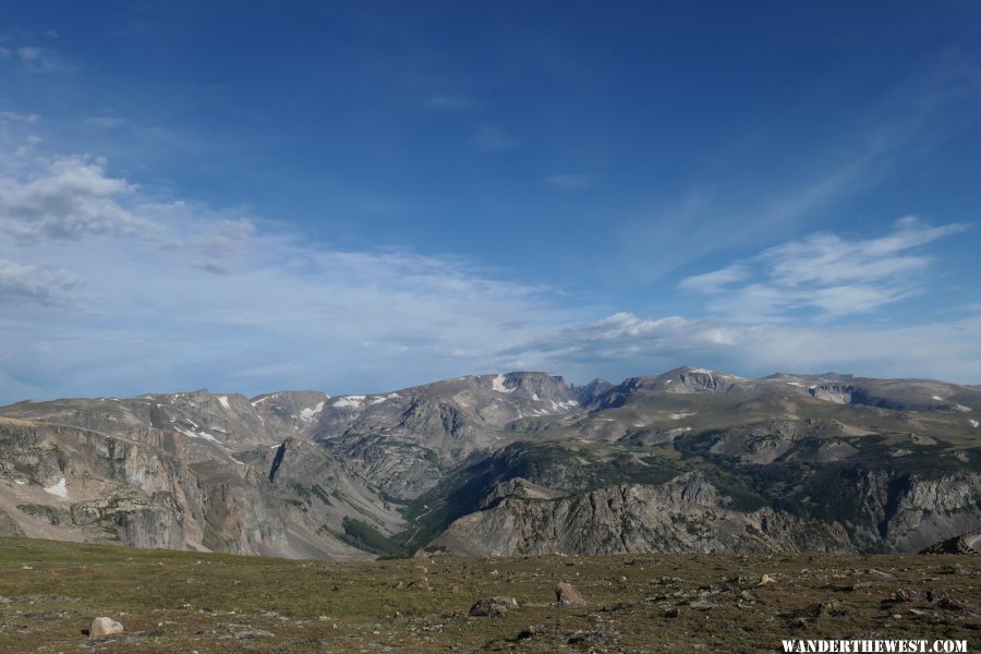
Fall 2019 trip west. View of the Bear Tooth Mountains from the Bear Tooth Highway near the Bear Tooth Pass. The "spike" mountain in the picture center right is The "Bear Tooth" visible from a short walk off the Bear Tooth Highway. The dirt road, lower center, is lower grade "high clearance" coming up from Rock Creek Canyon to a parking lot below Glacier Lake. Glacier Lake is barely visible above the "high clearance" road, center left.
0
Image META information
EXIF.SubSecTime
414
EXIF.SubSecTimeOriginal
414
EXIF.SubSecTimeDigitized
414
EXIF.CustomRendered
0
EXIF.DigitalZoomRatio
0/10
EXIF.FocalLengthIn35mmFilm
28
File Name
gallery_5179_211_7820433.jpg
Unix Timestamp
1581626512
Original File Size
8942080
File Type
2
Mime Type
image/jpeg
Sections Found
ANY_TAG, IFD0, THUMBNAIL, EXIF, INTEROP
HTML Sizes
width="5472" height="3648"
Image Height
3648
Image Width
5472
Color
TRUE
Byte Order Motorola
FALSE
Aperture F-Number
f/7.1
Thumbnail File Type
2
Thumbnail Mime Type
image/jpeg
Camera Make
Panasonic
Camera Model
DC-ZS200
Orientation
The 0th row is at the visual top of the image, and the 0th column is the visual left-hand side
X-Resolution
180/1
Y-Resolution
180/1
Resolution Unit
2
Software
Ver.1.0
Date Taken
2019:08:22 09:39:29
YCbCr Positioning
co-sited
Thumbnail Compression
JPEG Compression
Thumbnail Orientation
The 0th row is at the visual top of the image, and the 0th column is the visual left-hand side
Thumbnail X-Resolution
180/1
Thumbnail Y-Resolution
180/1
Thumbnail Resolution Unit
2
Thumbnail JPEG Interchange Format
30196
Thumbnail JPEG Interchange Format Length
4927
Thumbnail YCbCr Positioning
co-sited
Exposure Time
10/10000
F Number
71/10
Exposure Program
Landscape mode (for landscape photos with the background in focus)


