Jump to content


Photo
- - - - -

Fall into Autumn 2018


  • Please log in to reply
61 replies to this topic

#11 MarkBC

MarkBC

    The Weatherman

  • Site Team
  • 6,600 posts
  • LocationBend, Oregon

Posted 06 September 2018 - 05:26 PM

Well, for those folks not in the West  :(
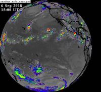
, there's GOES East.

Satellite_GOES16_abi_conus_20180906_171217_band02.jpg


Dang!  Sure looks humid back there!  :mellow:

Out West we keep summer humidity away with seasonal forest fires...keeps down the insect population, too.  :rolleyes:


...........................................


Here's a link to the page with all of the GOES satellite "products", courtesy the George C. Marshall Space Flight Center, Earth Science Branch.  Lots of cool satellite views at various wavelengths, which shows different kinds of atmospheric information.


Satellite_IFG15-15002018249.jpg

Looks like it would be an exciting time to sail from Cabo to Kona...  :blink:


  • 0

FWC Hawk (2005) on a Ford F250 Supercab, 6.8L V10 gas (2000)


#12 Smokecreek1

Smokecreek1

    Smokecreek1

  • Members
  • 2,763 posts
  • LocationNE Calif/NW Nev

Posted 06 September 2018 - 07:07 PM

Hey, Thanks  Mark for the web site-just need to buy a sail  boat now :huh: 
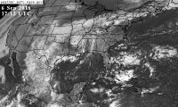
!  Boy the weather is strange here now! Less smoke, more clear days with warm nights and days above normal (high 80's low 90's). But a new fire near 120/395 junction  just blocked a proposed trip down south. Wonder if it's to early to go to the Steens/southern Oregon or maybe even just head up to one of my usual stops on the Modoc NF. Hmmm, big, puffy white/grey clouds seem to be coming in, maybe we might get some of that rain/T-storm stuff after all! Fun in the high desert!


Smoke


  • 0
Smokecreek1:99F1504x4with05Granby

#13 Foy

Foy

    Resident Geologist

  • Members
  • 1,295 posts
  • LocationRaleigh, NC

Posted 06 September 2018 - 07:47 PM

Welcome (back) to the land of humidity and hurricanes, Smoke!


All kidding aside, Greg Fishel is a real-world meteorologist with a degree from the Class A meteorology school at Penn State University. His WRAL crew does a great job of adapting the various national and international forecast models to the more localized region and I can put in a good word for their colleagues up in Tidewater, VA at WAVY.  


I'd sure keep tabs on WRAL, WAVY, and the National Hurricane Center's forecast plots over the course of this coming weekend and on into Monday-Tuesday of next week.  Generally speaking, once they are talking about forecast tracks and wind fields expected within about 3 days (72 hours), they're normally pretty much on-target.  


And, pay close attention to the bug-out routes from your Outer Banks (OBX) locality. You might can bug out pretty quickly from anywhere between Southern Shores to South Nags Head or even from Rodanthe-Waves-Salvo.  But getting gone from Avon, Buxton, Frisco, or Hatteras Village to the south or Carova Beach, Corolla, or Duck to the north can take many hours due to there being only a single two-lane highway (but I know the secret route between Duck and US 158 through Duck Woods).  And if by chance you're going to be on Ocracoke Island, you need to bug out about 48 hours before you know you need to.  


Yeah, bring some foul weather gear.


Good luck!


Foy


  • 1

#14 Old Crow

Old Crow

    Searching....

  • Members
  • 1,059 posts
  • LocationSouth Central PA

Posted 06 September 2018 - 11:34 PM

Thanks, Foy.  I'll keep an eye on the forecasts from the sources you mentioned.


Our rental is just a couple of blocks north of Whalebone Junction so we're very close to the US-64 bridge to Roanoke Island and west for bug-out.  I see the NC traffic web site shows traffic cams at several key locations and some construction is planned to start late next week on one of the bridges headed west out of Manteo.  Presumably that will get delayed if it's needed for evacuation traffic from OBX.


.


  • 0

'01 FWC Hawk shell on a '13 Tundra Double-Cab  + '19 Ford Transit van with Quigley 4x4 option


#15 Foy

Foy

    Resident Geologist

  • Members
  • 1,295 posts
  • LocationRaleigh, NC

Posted 07 September 2018 - 08:49 AM

Great catch on the bridge work planned. I'd forgotten about that. You can bet on it being postponed if a storm is nigh. Be sure to snag a Dune Burger, onion rings, and a chocolate shake from the venerable Dune Burger across the old Beach Road from Jeanette's Pier!
  • 0

#16 Foy

Foy

    Resident Geologist

  • Members
  • 1,295 posts
  • LocationRaleigh, NC

Posted 07 September 2018 - 05:00 PM

Thanks, Foy.  I'll keep an eye on the forecasts from the sources you mentioned.


.


Last comment:  The National Hurricane Center updates their forecasts with all updated eye tracks, wind field maps, etc 4 times daily at 0500, 1100, 1700, and 2300 hrs EDT.  


I wish I could tell you the 1100 today was an improvement from the 2300 last night, but I'd be lying if I did.


Good luck!


Foy


  • 0

#17 Old Crow

Old Crow

    Searching....

  • Members
  • 1,059 posts
  • LocationSouth Central PA

Posted 10 September 2018 - 09:21 PM

The Weather Channel has been showing a live-cam shot of Jeannette Pier (the one Foy mentioned above) and the angle looked very familiar.  It turns out the camera is on the porch of our rental house.


Surfchex Nag's Head (NC) camera


Hope the camera makes it through the storm!


A mandatory evacuation has been ordered starting tomorrow morning so we're packing for departure in the a.m.


Our stay has been cut short but on the bright side, I had a great "let's-talk-wolves" session this morning with the executive director of the Red Wolf Coalition (in Columbia, NC).


And on the way back to Nag's Head, I drove around in the Alligator River National Wildlife Refuge and saw five black bears-- including a mama and three of the cutest cubs ever.


.


  • 0

'01 FWC Hawk shell on a '13 Tundra Double-Cab  + '19 Ford Transit van with Quigley 4x4 option


#18 Foy

Foy

    Resident Geologist

  • Members
  • 1,295 posts
  • LocationRaleigh, NC

Posted 11 September 2018 - 12:25 PM

Cool on the red wolves/bear discussions and sightings.


Likely lotsa traffic headed out today.  By all means consider departing via US 64.  With the northern OBX evacuating via US 158 through Tidewater, VA, it's likely to be stop and roll all the way to Williamsburg, VA if not all the way to I-295.  Parts of Tidewater are under evacuation orders now, too.


I-95 northbound will likely be heavy throughout NC as others like you are departing early from the NC-SC coast.  I'd look at US 64 to Williamston, then NC 125/903 all the way to I-95 at Weldon.  Probably some agriculture traffic through there as farmers scramble to get corn and tobacco in before it's lost but to be sure still probably faster than a wholly clogged I-95.  


For that matter, you may want to look at holding US 64 to NC 98 west of Rocky Mount, over to NC 50 to US 15, and US 15 all the way through central VA to the Potomac at Point of Rocks.  Avoids all of DC, Richmond, and pretty much avoids towns and cities of all types.  Very nice countryside all through northern NC and the whole of central VA, too.


Foy


  • 0

#19 Smokecreek1

Smokecreek1

    Smokecreek1

  • Members
  • 2,763 posts
  • LocationNE Calif/NW Nev

Posted 11 September 2018 - 03:29 PM

Wow-you guys be safe!  All we got to worry about here. is high winds, above ave. heat, smoke and more fires and none -zero- zap-possibility of rain! Seems like Mother Nature is pissed at us this Fall!


Smoke


  • 0
Smokecreek1:99F1504x4with05Granby

#20 Foy

Foy

    Resident Geologist

  • Members
  • 1,295 posts
  • LocationRaleigh, NC

Posted 11 September 2018 - 04:33 PM

Here on the Right Coast we have earthquakes and wildfires only very rarely, and neither are often severe, while each occurs with the same lack of warning you Westerners are accustomed to.  But we do, on occasion, have these tropical cyclones known as hurricanes.  This one has the potential to be more severe than any to hit North Carolina since the year before I was born--1954.  Hazel was her name and she has been the benchmark for severity ever since.  Forecasting being what it was in 1954, the kids went to school on the October morning just before she hit the coast 150 miles from here in Raleigh. By early afternoon it was blowing so badly the authorities let the kids out of school early, to make their way in 40-50 mph winds and torrential rains!


Nowadays the forecasting is great and uncannily accurate, but that alone draws detractors who find the days-long wait unnerving.  Today I heard a phrase which strikes me as entirely on-point--Waiting for this hurricane is like being stalked by a turtle.


So, here we go......1100 Nat Hurricane Center update still has Raleigh with a bull's eye.  C'mon Ms Turtle, let's get this over with!


Foy


  • 0


0 user(s) are reading this topic

0 members, 0 guests, 0 anonymous users