Jump to content


Photo
- - - - -

Lolo Motorway - Idaho


  • Please log in to reply
2 replies to this topic

#1 Rockjok

Rockjok

    Advanced Member

  • Members
  • PipPipPip
  • 50 posts

Posted 03 September 2008 - 02:07 PM

Over the Labor Day weekend I travelled the Lolo Motorway (road 500) in the Bitterroot Range of Western Idaho for the first time. Tho' not shown on the following map I entered at Shotgun Creek, a couple miles from Lolo Pass. My original plan was to drive the Lolo westbound and then travel the Magruder Corridor (another "ultimate" track) but discovered it was closed due to fires. I ended up driving the hundred mile Lolo backroad both ways. I can really recommend doing this as it gives a much better perspective on the "ocean of mountains".

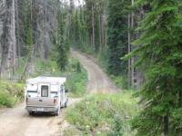
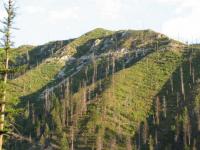
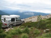
The Lolo follows a hundred+ miles of ridge crests and saddles rather than drainages and has some spectacular views. The road is narrow single lane with occasional turnouts and you need to be prepared to back up a ways if you meet someone. I definitely wish I had removed my camper jacks for this trip. Much of the road is an easy drive but I was definitely glad to have low range four wheel drive in some gnarly spots where the road had washed away. There are several mile-long hill climbs that will give you a boost of adrenaline. My average speed was 15 mph, ocassionally higher but often much lower. I'd allow a couple days to make it an interesting leisurely trip.

The road doesn't have an inside water channel and is generally sloped to allow water to drain to the outside. The outside dropoff is often precipitous. I ran across a coupe of truck campers that had stopped to decide whether they could negotiate a section without tipping over. Yes, it was that steep. I'm glad I've got a Falcon.

Be sure and have a good map. The USFS map is OK but I'd recommend the Benchmark Idaho atlas. Note that the delorme gazetteer is highly inaccurate in this area and IMHO is a waste of money. A decent saw is a good idea too as there are a lot of dead trees ready to fall and block the road. There are a couple of official campgrounds in the region but there are numerous primitive campsites around.

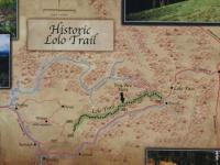
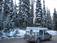
I find it cool that this is the actual route that Lewis and Clark took in Sept of 1805 and there are signs pointing out some of their campsites etc. It's hard to imagine travelling this country on foot when it's dry much less with 7 foot snowdrifts. The road is only passable a couple months of the year, this year it was clear in early August but it was snowing when I left on Sept 2nd. Contact the Powell Ranger district for info:

http://www.fs.fed.us...o_motorway.html

Attached Thumbnails

  • Copy of IMG_0229.JPG
  • Copy of IMG_0236.JPG
  • Copy of IMG_0083.jpg
  • Copy of IMG_0225.JPG
  • Copy of IMG_0265.JPG

  • 0

#2 craig333

craig333

    Riley's Human

  • Members
  • 8,026 posts
  • LocationSacramento

Posted 04 September 2008 - 02:09 AM

Another road to add to my list of places to go/see. Thanks for the nice pics.
  • 0

Craig K6JGV_________________________ 2004 2500 CTD 4X4 FWC HAWK 1960 CJ5


#3 GSBFree

GSBFree

    Advanced Member

  • Members
  • PipPipPip
  • 85 posts
  • LocationIdaho

Posted 04 September 2008 - 02:29 AM

Thanks for the write-up and pictures. We traveled the Magruder Corridor in July and were the first full size vehicles to get through this year....we cut out dozens of fallen trees, it was awesome!

It saddens me to hear of fires in the area. We were shocked by how much of the 100+ miles of the Magruder had been previously burned. But, what a place, nothing like it, in the 200+ mile round trip we saw one other vehicle....and where else in the country can you be surrounded by millions of wilderness acres. I have the Lolo route on my list as well, thanks for the write-up.
  • 0
'15 Tundra Double Cab
'08 Hawk


0 user(s) are reading this topic

0 members, 0 guests, 0 anonymous users