Jump to content


Photo
- - - - -

best way to find free/dispersed camping sites


  • Please log in to reply
26 replies to this topic

#11 park

park

    Senior Member

  • Members
  • 381 posts
  • LocationWickenburg, Arizona

Posted 19 October 2016 - 10:04 PM

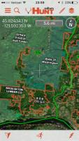
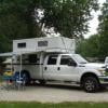
I seem to never plan ahead enough as  I never know where I'm going to camp.  I don't think I've ever left home and knew where I'd be camping at any given night. I simply go and then worry about the camping once I'm there.  I have never not been able to locate disbursed or somewhere free to camp.  Especially when travelling with the FWC.  I detest going off and god forbid have a reservation or have to be somewhere on a given date.  I travelled with a guy once who wanted to have a reservation for every night somewhere. We didn't last long!  I do carry maps and a GPS but seldom seem to use either to find camping.  I seem to just stumble upon or find great sites while out roaming around.  Amazing what one can find down a dirt road.  I will say that our National Parks are the exception when it comes to disbursed camping. There, reservations are almost a necessity.  Almost, as I have disbursed camp in a few NP's but it takes some doing.  If I'm visiting when the campgrounds are that full then I don't want to be there anyway.    My golden rule in finding a spot is.......do it well before the sun sets.


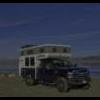
Another crappy camp spot found at the last minute!


Alaska2015-5-L.jpg


  • 2

Blogsite:  http://www.nowhereto...ur.blogspot.com

https://www.facebook.com/parkkitchings

Instagram Account @parkkitchings


#12 Vic Harder

Vic Harder

    Doctor Electric

  • Site Team
  • 4,996 posts
  • LocationCalgary, Alberta

Posted 20 October 2016 - 12:06 AM

that does indeed look like a terrible spot.... may you always find those or better!


  • 0

#13 clikrf8

clikrf8

    Senior Member

  • Members
  • 494 posts
  • LocationBellingham, WA

Posted 20 October 2016 - 01:30 AM

Benchmark and Avenza's PDF Maps app. I also use Ultimate Campground app. Like Park, we usually have no idea where we will be camping as we are explorers. I look at my paper/digital maps, find a USFS, BLM or state forest road then drive until we find a bench or clearing off the side of the road. It is an art and a science but I seem to find some cool places like old cemeteries (Delamar, NV), rock quarries, ghost towns, etc.

The Oregon Coast is the toughest place to find dispersed camping but I have found a few. Usually, it is necessary to find a national or state forest and drive a ways from the coast. One we especially liked not far off 101 is now posted. Fortunately, Oregon has great state parks and when we go in the off season, a standard site is $21 with free hot showers. Our dispersed camping during most of our trip allows us to splurge occasionally. Our recent 4 week trip to Idaho, Montana and Oregon cost $41 in camping fees, one of which was a state park.

Happy trails.
  • 0
2008 Ford F250 diesel 4x4 off road pkg 2013 Hallmark Ute http://www.clikrf8images.com/ http://clikrf8.wordp...com/2010/09/01/

#14 JaSAn

JaSAn

    Grumpy Old Man

  • Members
  • 1,110 posts
  • LocationMinnesota

Posted 20 October 2016 - 02:50 AM

I almost exclusively dispersed camp.


I find the best resource is the NFS Offload Vehicle Use Maps for the National Forest of interest.  I try to order them by mail before the trip but also stop by the NFS office and talk to the rangers.  I have found that they are the most accurate maps of the trails and the best ones give restrictions on roads and dispersed camping.  I also will download USGS topo maps to my laptop for use in planning and in the field (terrain is correct, back roads not so much).  I also carry Benchmark and Delorme Atlas for the states I travel through and Benchmark especially marks NF and BLM land well.  I also load topo maps to my Garmin hiking GPS.  Google Earth is good to use in non thickly forested areas.


I really enjoy wandering until I find a nice campsite, although it entails more driving.  I have also found that I have gotten better at spotting potential sites on maps the more I do it.


I usually start looking for a spot about 3 hours before sunset, get serious about 2 hours before, start looking for any place to park just before sunset.  Finding a campsite after dark sucks.


jim


  • 0
Sköldpaddan, a 1977 FWC Grandby
Renovating Skoldpaddan
2012 Ram 2500 4X4
1951 Dodge Power Wagon

#15 craig333

craig333

    Riley's Human

  • Members
  • 8,040 posts
  • LocationSacramento

Posted 20 October 2016 - 10:21 PM

I'll second the after dark thing (unless its a return visit). I pulled into Green Creek after dark a couple years ago. Nope, this spot won't do and then felt the tires spin on the wet grass. One of those times you're glad to have four wheel drive. Its funny, sometimes you'll find an abundance of nice spots and sometimes you don't.


  • 0

Craig K6JGV_________________________ 2004 2500 CTD 4X4 FWC HAWK 1960 CJ5


#16 OSUFlyer

OSUFlyer

    Advanced Member

  • Members
  • PipPipPip
  • 71 posts
  • LocationWahkiakum County, WA

Posted 21 October 2016 - 07:00 AM

I really like map books for planning, but for actual dispersed camping locations I try to obtain either ranger district maps or vehicle use maps. If you have phone service and a smart phone I like the landowner maps produced by OnX maps. Though designed for hunting I have located good camping spots by finding random public parcels. IMG_2567.JPG

Edited by OSUFlyer, 21 October 2016 - 07:01 AM.

  • 0

1997 OBS Ford 7.3 DSL 4x4
1985 Four Wheel Keystone


#17 clikrf8

clikrf8

    Senior Member

  • Members
  • 494 posts
  • LocationBellingham, WA

Posted 23 October 2016 - 04:15 AM

I really like map books for planning, but for actual dispersed camping locations I try to obtain either ranger district maps or vehicle use maps. If you have phone service and a smart phone I like the landowner maps produced by OnX maps. Though designed for hunting I have located good camping spots by finding random public parcels. attachicon.gifIMG_2567.JPG

We use that for Oregon and Washington. The maps are around $30 a years but we spend a lot of time in these two states. I used in my neighborhood as we lived in a rural area. It was pretty accurate. It did help us in eastern Washington which has little BLM land to decide if we should camp in this one area as it wasn't posted but there was a fence. It happened to be USFS property with  grazing allotment so we could camp there away from the fence, of course. 


  • 0
2008 Ford F250 diesel 4x4 off road pkg 2013 Hallmark Ute http://www.clikrf8images.com/ http://clikrf8.wordp...com/2010/09/01/

#18 hoyden

hoyden

    Lady Bug

  • Members
  • 1,459 posts
  • LocationCarbondale, IL

Posted 29 October 2016 - 04:29 AM

I prefer paper maps as well cuz all of my electronic supposed "offline" maps don't seem to ever work right.


IF I have signal, or often before I trip, I'll often consult https://freecampsites.net/


Edited by hoyden, 29 October 2016 - 04:29 AM.

  • 0

https://no-destination.org/ .:.  https://razorgirls.org/


2014 Tacoma DCLB + 2015 FWC Fleet


As I get braver I get stronger, and as I get stronger I get braver. It’ a good cycle.

#19 longhorn1

longhorn1

    Ouch, that stings!

  • Members
  • 2,826 posts
  • LocationCarmel, Indiana

Posted 29 October 2016 - 01:14 PM

Foy pointed us in the direction of the Benchmark atlas'. We used our Montana and Wyoming Benchmark daily. BLM & NFS lands clearly marked with many roads to try. jd

Sent from my SM-G900V using Wander The West mobile app

Edited by longhorn1, 29 October 2016 - 01:15 PM.

  • 0

http://texaslonghorns01.blogspot.com/


Ford F-250 Long bed, 2014 Grandby


#20 gvb1940@gmail.com

gvb1940@gmail.com

    Member

  • Members
  • PipPip
  • 11 posts

Posted 17 December 2016 - 11:04 PM

I see lots of threads here with info about downloading maps. I've looked at a few USGS maps, and I started to go blind trying to spot campsites.   I've seen and tried some of the apps that let you download maps.  All seem pretty good, but what about when you are miles from nowhere and DIDN'T download the map?Are there books of maps?  
 
And freecampsites.net is cool, but again, wondering what you do when off the 'net?  So, in general, I guess I am wondering what people do in order to find campsites in BLM or NF areas?

Check out an app called allstays
  • 0


0 user(s) are reading this topic

0 members, 0 guests, 0 anonymous users