Jump to content


Photo
- - - - -

More from S. AZ


  • Please log in to reply
3 replies to this topic

#1 Chel

Chel

    Member

  • Members
  • PipPip
  • 19 posts

Posted 12 March 2009 - 04:36 AM

After a few days of golf in Oro Valley I hit the road again. First stop, Tucson Mountain Park and Saguaro National Park west. Good hiking, the cactus and other thorny plants along the trails were too narrow for my mtn bike skills. The campground at Tucson Mtn Park is very large and loaded with MoHo's. There is no undeveloped camping here, although undeveloped sites are available in Ironwood National Monument NW of here.
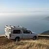
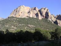
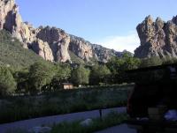
Next, Cochise Stronghold. This "sky island" in the Coronado National Forest is where Chief Cochise held off the feds for 15 years and he is said to be buried here. The rock walls are incredible and popular with climbers. There is a small developed campground. I had a nice night there and enjoyed the nature trail and Cochise trail, saw lots of deer and javelina. The second day I explored 4WD roads and primitive campsites. I stayed at a primo spot that has probably been in use for thousands of years. A large flat rock has the grinding pits used by the native people to prepare food and is adjacent to a large natural stone reflector oven.
3-9-09 012 compressed.JPG

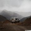
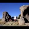
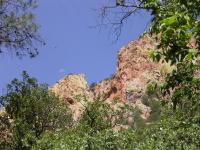
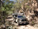
I traveled east to the next sky island, the Chiricahuas. Chiricahua National Monument is spectacular, be sure to drive to the top and hike the short trail to the grottos. The Bonita Creek campground is good. The NM has a lot of intricate CCC work, visible on the trails and buildings and celebrated in the visitor center. There are numerous small primitive and barely developed campgrounds outside the NM. Rucker Canyon Rd, Pinery Canyon Rd, Cave Creek Canyon RD and all the numbered side roads made for a few days of super hiking, mtn biking and 4WD exploration.3-9-09 024 compressed.JPG

A previus post about the Chiricahuas noted the presence of Border Patrol and ominous signs warning of illegal activity. I have seen these signs on every back road I have driven the last 3 weeks. The BP on the main roads is all business but I had some good conversations with officers on the back roads. I never felt threatened, however I camped in campgrounds when really close to the border and spent my 4WD and undeveloped campsite time 20 miles or more from the border.
  • 0
2008 Tundra Doublecab SR5 TRD, 5.7 V8, helper springs; 2008 FWC Hawk; Yakima Tracks/ Control Towers roof rack, Yakima Swingdaddy hitch rack; Champion Covers bicycle cover.

#2 SunMan

SunMan

    King Taco

  • Members
  • 2,362 posts
  • LocationOxnard, CA.

Posted 12 March 2009 - 02:31 PM

Nice report. Any pics from the grinding pits? Just a suggestion, but you might wanna increase the size of your pics a bit more for better effect. Thanks for posting.
  • 0

Sunman
2003 Four Wheel Camper -Hawk

2023 All Terrain Camper - Panther 
2006 Toyota Tundra Double Cab Limited 4WD
2017 Toyota Tundra Double Cab Limited 4WD


#3 marc

marc

    Fire Proof

  • Members
  • 1,121 posts
  • LocationSouth Shores California

Posted 13 March 2009 - 12:39 AM

Hey Chel

Thanks for the report and pics. As Sonny mentioned we like pics, bigger is better.
  • 0

2016 Sprinter Silver Gray 144 Std. Roof 4x4. 3.0 diesle, Cooper "Dicoverer" ST Maxx 255/85/16


#4 highz

highz

    Retreaded

  • Members
  • 1,816 posts
  • LocationSacramento Mountains, NM

Posted 13 March 2009 - 05:56 PM

This seems like an appropriate thread to post some pics of the Cave Creek area in the Chiricahuas. I went there for a few days at the tail end of last July.

By the way, if you are interested, New Mexico State U. has a documentary on the Chiricahuas that you can download for free from iTunes. Go to the iTunes Store, then iTunes U, then Universities and Colleges, then New Mexico State U., then click on the "Southwest Horizons" Series. Whew. I suppose you could also just do a search on Southwest Horizons ...

The first two pics are from Sunny Flat campground. You can see a few caves in the cliff faces. No, I didn't climb up there.

The third pic of cave and Moon was taken while walking along Cave Creek

There was a thunderstorm during the night (wish I'd had my FWC then), and Cave Creek overflowed it's banks lower down the canyon. The fourth pic is Cave Creek at Sunny Flat after the rain.

Attached Thumbnails

  • Sunny_Flat_1_small.jpg
  • Sunny_Flat_2_small.jpg
  • Cave_Moon_Small.jpg
  • Cave_Creek_small.jpg

  • 0

'99 Ford Ranger XLT, '08 FWC Eagle
-------------
“the clearest way into the Universe is through a forest wilderness.” - John Muir


0 user(s) are reading this topic

0 members, 0 guests, 0 anonymous users