

Southern-UT/Northern-AZ in Early-May
Started by
MarkBC
, Mar 13 2011 11:01 PM
55 replies to this topic
#11

generubin
-
- Members
- 626 posts
Electric Baja
- LocationVentura, California
Posted 14 March 2011 - 07:37 PM
ok, I have another "Secret" camping spot along the 4WD road from Comb Ridge to Moon House Ruin. But, I'm not telling.
From Baja to the Arctic and all places between!
www.generubinaudio.com
Dodge 4x4 2500 Cummins, 6 spd manual, ATC Ocelot Shell. Tesla Model S, 85KWH, 2018 Tesla Model 3 (3 of them!!)
#12
chnlisle
-
- Members
- 3,811 posts
Post Master
- LocationThe Old Pueblo
Posted 14 March 2011 - 09:20 PM
I'll bet he'll give it up if you ask nicely.
Special Engel Pricing For WTW Members
Click here to see my ATC Cougar
JayAronowSales.com
(520)579-9610
jayaronow@gmail.com
#13
randygirl
-
- Members
- 170 posts
Senior Member
- LocationSW Florida
Posted 15 March 2011 - 02:15 PM
Sounds perfect.
I was planning on leaving Florida around Easter and heading that way. Not sure exctly where to go, so I am open.
Keep me posted, would love to thabnk some of you in person for all the advice!!
Randy
I was planning on leaving Florida around Easter and heading that way. Not sure exctly where to go, so I am open.
Keep me posted, would love to thabnk some of you in person for all the advice!!
Randy
2006 GMC Sierra 2500HD 4x4 (LBZ) Duramax Diesel& 2002 Hawk, 2 dogs and a lust for adventure ;-)
#14
MarkBC
-
- Site Team
- 6,602 posts
The Weatherman
- LocationBend, Oregon
Posted 15 March 2011 - 02:22 PM
Sounds like you could arrive in the area at the right time.Sounds perfect.
I was planning on leaving Florida around Easter and heading that way. Not sure exctly where to go, so I am open.
Keep me posted, would love to thabnk some of you in person for all the advice!!
Randy

It's a big area...so at some point a plan will need to gel around exactly where (and when).
FWC Hawk (2005) on a Ford F250 Supercab, 6.8L V10 gas (2000)
#15
randygirl
-
- Members
- 170 posts
Senior Member
- LocationSW Florida
Posted 15 March 2011 - 02:24 PM
I've been lurking, not posting much. Busy getting the funds together for the summer.
I do have 2 large dogs.........so I hope they are welcome.
Will keep my eyes on this thread for plans!
Thanks.
I do have 2 large dogs.........so I hope they are welcome.
Will keep my eyes on this thread for plans!
Thanks.
2006 GMC Sierra 2500HD 4x4 (LBZ) Duramax Diesel& 2002 Hawk, 2 dogs and a lust for adventure ;-)
#16
Barko1
-
- Members
- 1,635 posts
Senior Member
- LocationSouthern Appalachians
Posted 16 March 2011 - 01:33 AM
I do have 2 large dogs.........so I hope they are welcome.
Thanks.
They are probably better looking and mannered than most on here
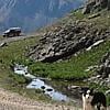
 I usually have three or four with me. East of Monticello UT early this month.
Granby on an F250 in S. NM
#17
MarkBC
-
- Site Team
- 6,602 posts
The Weatherman
- LocationBend, Oregon
Posted 26 March 2011 - 02:27 PM
Hey! Just thought I'd bump this a bit, but mainly to add a bit. Consider the Toroweap (aka Tuweep) area of the Grand Canyon in the Arizona Strip -- I am. In fact, I'm definitely hitting it on this trip.
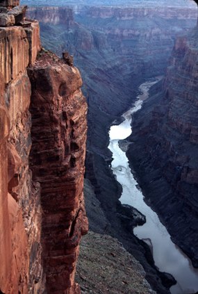
The photo above is from the Grand Canyon NP page for the area.
I've been there once before, back in 1994 -- very cool (a couple of my photos from that trip below):


What's so cool about this spot at GC is that, while the drop to the river is "only" 3000' from the rim -- not a mile, it's an actual drop....if you got a good run at it in your rig you might be able to hit the water! The small N.P. campground (semi-primitive) is quite-near the edge. The area is little-visited (little for an NP).
A couple of miles away is a trailhead for a day-hike down to the river. I did that last time...when I was in much better shape than now . I watched rafting groups -- and a couple of kayaks -- go through the enormous, house-sized, Lava Rapids, which is near the bottom of the trail.
I've already checked with the BLM and NP and they both say it's accessible now -- since it's a couple-thousand feet lower than the more-well-known "main" North Rim area there's a lot less snow. 60 miles of graded dirt/gravel road from Utah 389. The BLM tells me that the road is mostly kept open 'cause there are uranium mines in the area that need access. (I'm going to borrow one of those lead aprons from my dentist for the trip
  )
)
The photo above is from the Grand Canyon NP page for the area.
I've been there once before, back in 1994 -- very cool (a couple of my photos from that trip below):
What's so cool about this spot at GC is that, while the drop to the river is "only" 3000' from the rim -- not a mile, it's an actual drop....if you got a good run at it in your rig you might be able to hit the water!
The small N.P. campground (semi-primitive) is quite-near the edge. The area is little-visited (little for an NP).A couple of miles away is a trailhead for a day-hike down to the river. I did that last time...when I was in much better shape than now
. I watched rafting groups -- and a couple of kayaks -- go through the enormous, house-sized, Lava Rapids, which is near the bottom of the trail.I've already checked with the BLM and NP and they both say it's accessible now -- since it's a couple-thousand feet lower than the more-well-known "main" North Rim area there's a lot less snow. 60 miles of graded dirt/gravel road from Utah 389. The BLM tells me that the road is mostly kept open 'cause there are uranium mines in the area that need access.
(I'm going to borrow one of those lead aprons from my dentist for the trip )
FWC Hawk (2005) on a Ford F250 Supercab, 6.8L V10 gas (2000)
#18
Dughlas Stiubhart
-
- Members
- 1,474 posts
It's good to be Stew
- LocationSE CO
Posted 26 March 2011 - 03:37 PM
Nice pics of Toroweep, Mark. I think I'd like to visit there for a bit this spring.
Stew
2007 Custom All Terrain Camper Panther Shell on 2012 Toyota Tundra 4x4 in SE CO
#19
dsrtrat
-

- Members
- 259 posts
Senior Member
Posted 26 March 2011 - 07:01 PM
Here is some information on the uranium mining issue that is going on on the Arizona Strip area and also on the area south of Grand Canyon national park. This is a pretty big deal with mining proposed to go on for 40 years and require the ore to be trucked to a mill in Utah over the very roads you will be traveling to get to Toroweap. The sad thing is that it is just industrial greed and not need that is driving this mining.
http://www.azcentral.com/arizonarepublic/news/articles/0102uranium02.html?&wired
Dsrtrat
http://www.azcentral.com/arizonarepublic/news/articles/0102uranium02.html?&wired
Dsrtrat
Hey! Just thought I'd bump this a bit, but mainly to add a bit. Consider the Toroweap (aka Tuweep) area of the Grand Canyon in the Arizona Strip -- I am. In fact, I'm definitely hitting it on this trip.
The photo above is from the Grand Canyon NP page for the area.
I've been there once before, back in 1994 -- very cool (a couple of my photos from that trip below):
What's so cool about this spot at GC is that, while the drop to the river is "only" 3000' from the rim -- not a mile, it's an actual drop....if you got a good run at it in your rig you might be able to hit the water!
A couple of miles away is a trailhead for a day-hike down to the river. I did that last time...when I was in much better shape than now
I've already checked with the BLM and NP and they both say it's accessible now -- since it's a couple-thousand feet lower than the more-well-known "main" North Rim area there's a lot less snow. 60 miles of graded dirt/gravel road from Utah 389. The BLM tells me that the road is mostly kept open 'cause there are uranium mines in the area that need access.
#20
generubin
-
- Members
- 626 posts
Electric Baja
- LocationVentura, California
Posted 26 March 2011 - 07:06 PM
Here is some information on the uranium mining issue that is going on on the Arizona Strip area and also on the area south of Grand Canyon national park. This is a pretty big deal with mining proposed to go on for 40 years and require the ore to be trucked to a mill in Utah over the very roads you will be traveling to get to Toroweap. The sad thing is that it is just industrial greed and not need that is driving this mining.
http://www.azcentral.com/arizonarepublic/news/articles/0102uranium02.html?&wired
Dsrtrat
I am thinking with the nuclear tragedy going on in Japan and many countries stopping, even reversing their nuclear policies, uranium prices are about to crash. Hopefully, a final nail in the coffin to the uranium industry.
From Baja to the Arctic and all places between!
www.generubinaudio.com
Dodge 4x4 2500 Cummins, 6 spd manual, ATC Ocelot Shell. Tesla Model S, 85KWH, 2018 Tesla Model 3 (3 of them!!)


0 user(s) are reading this topic
0 members, 0 guests, 0 anonymous users

