I loved the big campgrounds as a kid. The rangers in their funny hats. Singing songs at the amphitheatre. Glad my dad did both kinds of camping. Though I prefer the quieter kind now you should never forget our national monuments, parks, etc are there for a reason.
P.S. great trip report


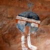
John Day Fossil Beds National Monument
Started by
UglyScout
, Jun 15 2011 03:58 AM
13 replies to this topic
#11

craig333
-

- Members
- 8,023 posts
Riley's Human
- LocationSacramento
Posted 16 June 2011 - 02:54 AM
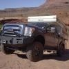
Craig K6JGV_________________________ 2004 2500 CTD 4X4 FWC HAWK 1960 CJ5
#12
Dughlas Stiubhart
-
- Members
- 1,474 posts
It's good to be Stew
- LocationSE CO
Posted 16 June 2011 - 01:54 PM
Thanks for the report and pics, Ugly!
Stew
2007 Custom All Terrain Camper Panther Shell on 2012 Toyota Tundra 4x4 in SE CO
#13
ntsqd
-

- Members
- 2,881 posts
Custom User Title
- LocationNorth So.CA
Posted 17 June 2011 - 12:50 AM
Great thread! Thanks for calling up my own memories of the area. My grandparents lived in Powell Butte and we went camping at least once every summer. This was back when Walton Lake was unknown and only the fishermen really knew about the Crooked River Gorge section there between Prineville and the dam. We only camped in that gorge once, but it is one of the spots that I most clearly remember.
You ought to have seen the firewood stack that the ranch house between those two turns had........
BTW, in the Kershaw Knives catalog there is a model called the "D.W.O." That stands for Delly Wade Officer, of the Officer Ranch SE of Paulina at the foot of the Strawberry's. He was killed in a hunting accident of some sort. How exactly the knife came to be I do not know.
A little story about that road, as told to me by Pat Miller of Miller Ranch near Paulina and confirmed by Clyde Quigley - log truck driver & former Redmond Coast to Coast owner. The northern of the two 90* turns in that road on the Section Lines about 1/2 way between Paulina and Prineville has(had?) a large tree in the triangle of the current radiused highway turn and the original sharp 90 turn. It is a nice spot to take a break. Back when they were logging the Strawberry Mtn's it was sometimes filled with a log or two. Seems that when the weigh station is open and a driver thinks that he might be heavy they pull down in there and peel a couple off the truck.snipped....
By the way: Next time you're in the Prineville area and headed east (or in the John Day/Canyon City area heading west) I recommond taking the highway/road that runs south/east from Prineville to Post (geo-center of Oregon), Paulina, Izee then connects to US395 south of Canyon City. A nice secondary highway to explore (though NOT a shortcut) with a real middle-of-nowhere feel in places. Mostly open country with big views in places. Can be beautiful in spring with wildflowers. Lots of gravel/dirt roads take off into the National Forest and BLM both north and south from that road. I've done it as a day-drive loop from Bend (in combination with the main Highway 26) more than once.
You ought to have seen the firewood stack that the ranch house between those two turns had........
BTW, in the Kershaw Knives catalog there is a model called the "D.W.O." That stands for Delly Wade Officer, of the Officer Ranch SE of Paulina at the foot of the Strawberry's. He was killed in a hunting accident of some sort. How exactly the knife came to be I do not know.
Thom
Where does that road go?
Where does that road go?
#14
Silvertip47
-
- Members
- 478 posts
The Chair Bandit
- LocationBoise, Idaho
Posted 19 June 2011 - 12:57 PM
Thanks for sharing!! I've driven by the signs many times but never stopped. Now I need to do that!!! 
2011 F250 SCAB 6.2 gas 373 FX4 Lariat 4" Lift 35" Toyos 16.5 Warn Locked & Loaded
2007 SunLite


0 user(s) are reading this topic
0 members, 0 guests, 0 anonymous users

