Jump to content


Photo
- - - - -

Abert Rim, south-central Oregon


  • Please log in to reply
19 replies to this topic

#1 MarkBC

MarkBC

    The Weatherman

  • Site Team
  • 6,602 posts
  • LocationBend, Oregon

Posted 05 July 2010 - 02:05 AM

This trip is still in progress -- I'm still out here...but I wanted to post a few photos now since I can.


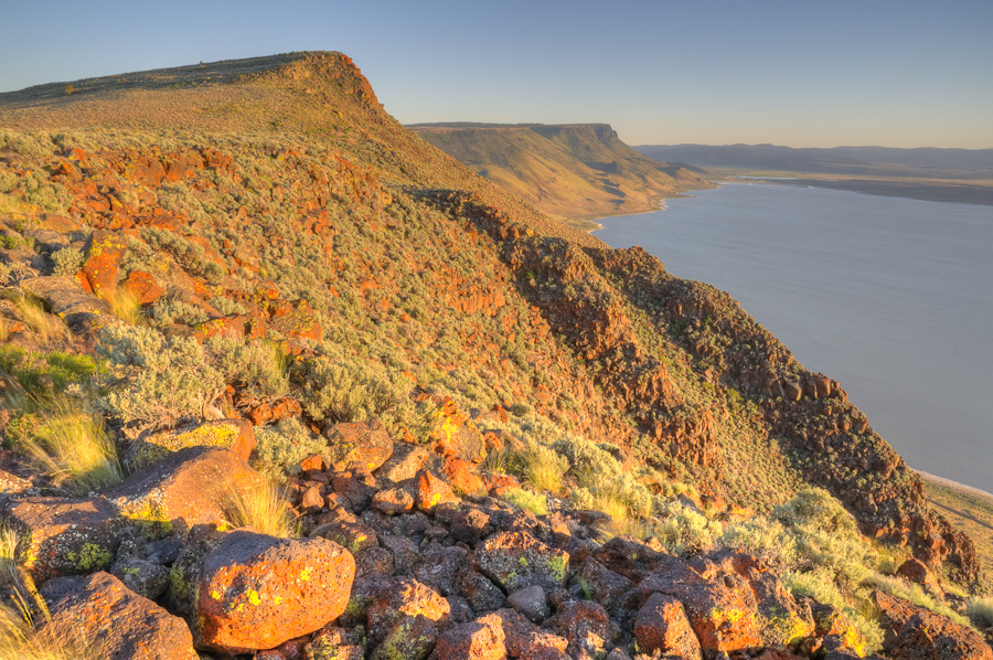
My approximate location is Lat 42° 36.8' N, Lon 120° 9.8'W, at 5750' elevation, camped about 1/4 mile from the edge of Abert Rim -- a basalt fault block, west-facing scarp. Abert Lake (alkaline, home only to brine shrimp and similar tiny critters -- and the birds who eat them) is at the base. At its highest point, Abert Rim has more than 2000 feet of relief -- a lot of it dead-vertical -- over the basin below. US 395 travels along the base, next to Abert Lake.

I got here mid-day Saturday July 3, wandered over to the rim, and inadvertently spooked a herd of 25 bighorn sheep -- they ran and ran and ran. Bighorns seem to be the most skittish of all hooved wild animals (except maybe for "wild" horses...but to purists they're not wild, they're "feral", so maybe they don't count).

Anyway, here are a few shots I took a last night, a little before sunset:

Posted Image

Posted Image

Posted Image

Here's a link to a panorama I made from shots taken today on the Rim -- a QuickTimeVR:
Abert Rim Pano 01.
The pano shots were taken midday, so the light was crappy...but it was fun to do anyway. I plan to do another one in "good" light tonight and/or tomorrow morning. This one used a wide-angle lens -- 24mm "equivalent", 12 images in portrait mode -- enjoy the distortion (but don't view in an altered state or you might freak out Posted Image ).

Speaking of altered states -- and modified photography -- these are/were all HDR images (tonal composites of 3 different exposures).
  • 0

FWC Hawk (2005) on a Ford F250 Supercab, 6.8L V10 gas (2000)


#2 DirtyDog

DirtyDog

    Captain Leisure

  • Site Team
  • 3,157 posts
  • LocationEugene, Oregon

Posted 05 July 2010 - 05:05 AM

Fantastic Mark! Where is you access point for the Abert Rim? That's a pretty large/obscure geographical feature. I'm intrigued!
  • 0

#3 MarkBC

MarkBC

    The Weatherman

  • Site Team
  • 6,602 posts
  • LocationBend, Oregon

Posted 05 July 2010 - 05:52 AM

Fantastic Mark! Where is you access point for the Abert Rim? That's a pretty large/obscure geographical feature. I'm intrigued!


I came in from the north. Just north of Abert Lake on 395, the Hogback Road takes off to the southeast towards the Warner Lakes Valley and Hart Mt. Refuge (I'm sure you know of it). About 3+ miles down the Hogback a minor dirt road heads off to the south (it's on topo maps and BLM maps). At first it's OK...but not for long: it took me almost 2 hours to go 13 miles, to where I'm camped. Quite rocky in spots, though not technical. Ruts indicated that it had been muddy, too, but not now.

The easy way to access Abert Rim -- in fact, to a steeper/higher part of the rim -- is from the south off Highway 140 (after turning east off 395, 6 miles north of Lakeview): head north at the sign that indicates Mud Springs C.G., etc. Then look at a Forest Service map and take whatever road appears to get close to the rim -- it's not hard. Much easier than getting to where I am...though of course not as isolated/private. (and yet, I was "visited" by 2 different parties of pre-hunters today -- scouting in preparation for Pronghorn antelope season).
  • 0

FWC Hawk (2005) on a Ford F250 Supercab, 6.8L V10 gas (2000)


#4 MarkBC

MarkBC

    The Weatherman

  • Site Team
  • 6,602 posts
  • LocationBend, Oregon

Posted 05 July 2010 - 08:12 AM

Here's a new-and-improved QuickTime VR panorama from Abert Rim -- better location, better light, better focal length:
Abert Rim Pano 3
It's kinda big -- 1.8MB, but it needs to be. QuickTime viewer/plugin is needed, but if you have iTunes, you should have QuickTime. 120 individual images went into this -- 5 exposures at each of 24 angular positions in the circle of view.
I took some "regular" stand-alone photos, too -- which I'll post -- but the pano captures the big view available from this spot in a way that a single photo can't.
By the way: My truck and camper are just barely visible out on the plateau where I'm still camped -- an unnatural-looking white/grey spot. Zoom in and you may see it. Posted Image
  • 0

FWC Hawk (2005) on a Ford F250 Supercab, 6.8L V10 gas (2000)


#5 Dughlas Stiubhart

Dughlas Stiubhart

    It's good to be Stew

  • Members
  • 1,474 posts
  • LocationSE CO

Posted 05 July 2010 - 01:36 PM

Nice shots, Mark. Is that Winter Rim off there to the west?
  • 0

Stew


2007 Custom All Terrain Camper Panther Shell on 2012 Toyota Tundra 4x4 in SE CO


#6 MarkBC

MarkBC

    The Weatherman

  • Site Team
  • 6,602 posts
  • LocationBend, Oregon

Posted 05 July 2010 - 02:27 PM

Nice shots, Mark. Is that Winter Rim off there to the west?

Thanks, Stew. Yes, Winter Rim is the far-western horizon. In the second pano (which I mysteriously call "3") there's a huge duststorm coming off the south end of Summer Lake (a common occurrence) that rises in front of part of Winter Rim.
  • 0

FWC Hawk (2005) on a Ford F250 Supercab, 6.8L V10 gas (2000)


#7 marc

marc

    Fire Proof

  • Members
  • 1,121 posts
  • LocationSouth Shores California

Posted 05 July 2010 - 03:30 PM

Nice pics MarkBC. Keep them coming.

marc
  • 0

2016 Sprinter Silver Gray 144 Std. Roof 4x4. 3.0 diesle, Cooper "Dicoverer" ST Maxx 255/85/16


#8 MarkBC

MarkBC

    The Weatherman

  • Site Team
  • 6,602 posts
  • LocationBend, Oregon

Posted 05 July 2010 - 04:09 PM

Nice pics MarkBC. Keep them coming.

marc


Thanks, marc. Here's another:

Posted Image


Now I gotta drop the top and head home -- starting with 13 miles of slow road...and back to work tomorrow. Posted Image
  • 0

FWC Hawk (2005) on a Ford F250 Supercab, 6.8L V10 gas (2000)


#9 Dughlas Stiubhart

Dughlas Stiubhart

    It's good to be Stew

  • Members
  • 1,474 posts
  • LocationSE CO

Posted 05 July 2010 - 05:30 PM

We're sorry you have to go, Mark!
  • 0

Stew


2007 Custom All Terrain Camper Panther Shell on 2012 Toyota Tundra 4x4 in SE CO


#10 MarkBC

MarkBC

    The Weatherman

  • Site Team
  • 6,602 posts
  • LocationBend, Oregon

Posted 06 July 2010 - 02:39 AM

I got home OK (though because of previous stupidity on my part -- passing by a gas station because I thought the one that was formerly closed would be open -- it wasn't, so I had to add about 50 miles going out of my way to get truck fuel). But because of my detour for truck fuel I drove by the base of the Abert Rim, so I got some "full-frontal" photos; here's one. The overall top-to-bottom height is about 2000 feet, so the sheer-vertical section at the top is about 400 feet. From the southern access point you can drive to near the rim and hang your feet over the edge. Posted Image The southern end of Abert Rim -- back out of sight from the edge shown in the photos -- is Fremont National Forest, with Ponderosa pines -- very different from the area where I camped this weekend just a few miles to the north.

Posted Image


More exciting to me, though was the taking of the photos. I pulled over to the edge of US 395 and walked across to the fence with my camera. As I approached the fence I heard a familiar noise and saw a familiar sight -- a coiled rattlesnake giving me its traditional greeting! Here are a couple of pictures of the cutie. I think snakes are cool -- even rattlesnakes. Posted Image
Posted Image


Posted Image
  • 0

FWC Hawk (2005) on a Ford F250 Supercab, 6.8L V10 gas (2000)


0 user(s) are reading this topic

0 members, 0 guests, 0 anonymous users