Jump to content


Photo
- - - - -

GPS software question


  • Please log in to reply
51 replies to this topic

#21 leadsled9

leadsled9

    Senior Member

  • Members
  • 935 posts
  • LocationLivermore, CA

Posted 12 February 2011 - 12:16 AM

Here is an example from the Garmin Topo maps. Hiking trails are indicated in dark gray dotted lines. It can be expensive but it depends on what you are trying to accomplish like Leadsled states.


RJones,

How did you get your screenprint into a .jpeg format?
  • 0

2010 Ford F250 4X4; 6.4 Powerstroke Diesel; Warn 16.5 winch; Airlift Springs; Transfer Flow 47 gal. fuel tank, BDS 4" lift kit, BDS dual steering stabilizer with upgraded Fox 2.0 shocks, Toyo 35X12.50X18 Open Country M/T tires, Pro Comp wheels;  2008 FWC Hawk Camper;  2000 Toyota Tundra.


#22 SunMan

SunMan

    King Taco

  • Members
  • 2,362 posts
  • LocationOxnard, CA.

Posted 12 February 2011 - 02:31 AM

Wow, Thanks for the info guys especially all the tips and tricks Leadsled. Lots of good info there.

It really sounds like that SW US package would suit me perfectly and then put Baja on another card. I don't really see myself planning routes or using it for city navigation (I have an iPhone for that). I plan to mostly use it to mark waypoints for turns to certain places, more for situational awareness than anything else. And also for hiking, especially in DV when wandering up canyons with many forks where trails aren't always existent. But who knows, the more I become adept I'm sure i'll find many more uses. I also dig the ability to print maps to where you are going, i can see lots of savings there. Again, forgive my ignorance on the subject.
  • 0

Sunman
2003 Four Wheel Camper -Hawk

2023 All Terrain Camper - Panther 
2006 Toyota Tundra Double Cab Limited 4WD
2017 Toyota Tundra Double Cab Limited 4WD


#23 RJones

RJones

    Senior Member

  • Members
  • 237 posts
  • LocationMtns of Colorado

Posted 12 February 2011 - 05:23 PM

Alt Print Screen and then paste into Microsoft Paint and save as JPEG file.


RJones,

How did you get your screenprint into a .jpeg format?


  • 0
RJones

02 Eagle - 07 Tacoma TRD

#24 MarkBC

MarkBC

    The Weatherman

  • Site Team
  • 6,602 posts
  • LocationBend, Oregon

Posted 12 February 2011 - 05:42 PM

RJones,
How did you get your screenprint into a .jpeg format?

FYI: A most-excellent free image editor (and viewer) is Irfanview.
I own and use Adobe Lightroom and Photoshop for complicated stuff, but for simple stuff -- format conversion (including batch-conversion/renaming), cropping, resizing-for-web/email, lite editing -- nothing beats Irfanview.
IMHO. Posted Image
(It is total freeware, but donations to this generous German guy are accepted, and I've done so since I've used it so much for many years.)
  • 0

FWC Hawk (2005) on a Ford F250 Supercab, 6.8L V10 gas (2000)


#25 HERR42

HERR42

    01110010110101

  • Members
  • 797 posts
  • LocationSacramento, Ca

Posted 12 February 2011 - 05:51 PM

as posted before....


free usgs topos here http://libremap.org/data/
  • 0
Jeff Herr WW6L '07 Hawk & '00 F250 SuperDuty CrewCab, Warn 12K, BFG AT KO 'E' rated, TransferFlow 48Gal tank

#26 MarkBC

MarkBC

    The Weatherman

  • Site Team
  • 6,602 posts
  • LocationBend, Oregon

Posted 12 February 2011 - 06:05 PM

as posted before....
free usgs topos here http://libremap.org/data/


Wow -- I wasn't aware of this somehow...Posted Image

I have the NatGeo TOPO state series' for all the western states, so I don't actually need this now...but for anyone who hasn't already spent $80-$100/state, this looks great for computer-viewing and printing.
  • 0

FWC Hawk (2005) on a Ford F250 Supercab, 6.8L V10 gas (2000)


#27 Alley-Kat

Alley-Kat

    Elder Statesman

  • Members
  • 989 posts
  • LocationPacific Ocean

Posted 12 February 2011 - 06:10 PM

RJones,

How did you get your screenprint into a .jpeg format?


I use screen capture software all the time.

My favorite is ScreenHunter, they have a FREE version.

http://wisdom-soft.c...hunter_free.htm

ScreenHunter automatically makes JPG images at the same image resolution as your monitor resolution.

The technique I use the most is the ability to select a rectangular image from the entire screen, so, I just get the part I want.

If I can get it on my screen, I can capture it and I can also print it.

- - - - - - - - - - - - - - - - - - - - - -

This is only my second message on WTW, so let's see if I can figure out how to post a JPG image here.

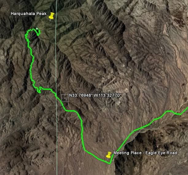
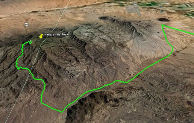
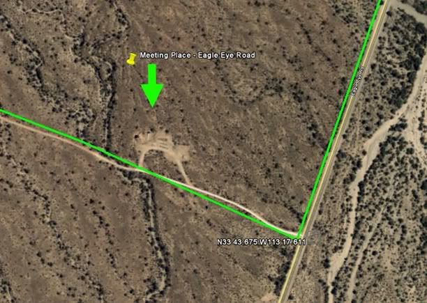
Here's a couple of screen captures of a path in GoogleEarth that I used to promote a Honda Trail bike (CT90's & CT110's) ride up to the top of Harquahala peak in Arizona. These kind of screen captures can help possible participants get a feel for the route of the ride.

Almost looking straight down. The Lat & Lon are for the Monterey mine, a little off the ride route.

Posted Image


A more oblique view, to get the feel of the terrain.


Posted Image

Our meeting place.

Posted Image

- - - - - - - - - - -

BTW, this is great thread on GPS software... the detailed info really helps me... THANKS.

- - - - - - - - - -

Hum, seems my method of posting images is a little different.
Note to Admin: If this is not acceptable, just let me know.
  • 0

#28 MarkBC

MarkBC

    The Weatherman

  • Site Team
  • 6,602 posts
  • LocationBend, Oregon

Posted 12 February 2011 - 06:29 PM

Those using Windows 7 may have found its built-in "Snipping Tool" very handy for screen captures, too.
It permits selection of rectangular areas as well as free-form selections.
  • 0

FWC Hawk (2005) on a Ford F250 Supercab, 6.8L V10 gas (2000)


#29 leadsled9

leadsled9

    Senior Member

  • Members
  • 935 posts
  • LocationLivermore, CA

Posted 12 February 2011 - 08:19 PM

Wow -- I wasn't aware of this somehow...Posted Image

I have the NatGeo TOPO state series' for all the western states, so I don't actually need this now...but for anyone who hasn't already spent $80-$100/state, this looks great for computer-viewing and printing.


The Nat Geo Topo application is still very handy to have while roaming.....since you may not have an internet (probably won't) connection when you are in the boonies. It always seems I need a map I didn't plan on needing.

Also, it's great to integrate the gps unit with the maps....to show waypoints etc.
  • 0

2010 Ford F250 4X4; 6.4 Powerstroke Diesel; Warn 16.5 winch; Airlift Springs; Transfer Flow 47 gal. fuel tank, BDS 4" lift kit, BDS dual steering stabilizer with upgraded Fox 2.0 shocks, Toyo 35X12.50X18 Open Country M/T tires, Pro Comp wheels;  2008 FWC Hawk Camper;  2000 Toyota Tundra.


#30 leadsled9

leadsled9

    Senior Member

  • Members
  • 935 posts
  • LocationLivermore, CA

Posted 12 February 2011 - 08:44 PM

Those using Windows 7 may have found its built-in "Snipping Tool" very handy for screen captures, too.
It permits selection of rectangular areas as well as free-form selections.


Thanks. I have Windows 7 and did not know about the snipping tool.
  • 0

2010 Ford F250 4X4; 6.4 Powerstroke Diesel; Warn 16.5 winch; Airlift Springs; Transfer Flow 47 gal. fuel tank, BDS 4" lift kit, BDS dual steering stabilizer with upgraded Fox 2.0 shocks, Toyo 35X12.50X18 Open Country M/T tires, Pro Comp wheels;  2008 FWC Hawk Camper;  2000 Toyota Tundra.


0 user(s) are reading this topic

0 members, 0 guests, 0 anonymous users