Jump to content


Photo
- - - - -

GPS software question


  • Please log in to reply
51 replies to this topic

#11 ski3pin

ski3pin

    Belay On

  • Site Team
  • 15,346 posts
  • LocationSierra Nevada Range

Posted 10 January 2011 - 03:51 PM

This may not be what you're looking for, since it doesn't load onto your GPS -- it requires a computer...but I've been very happy with the National Geographic TOPO series of state maps. I've bought a set for each of the 11 western-US states. I've loaded them onto my laptop computer, which I always bring along when truck-camping. I can connect my GPS to the laptop and it will show my current position and track a route on the TOPO map on the laptop, and I can transfer waypoints and routes between GPS and TOPO on the laptop, but the TOPO maps themselves can't be transferred to the GPS.
If I need a truly portable version of a map I can print one out from the software...as long as I've brought my portable printer along or do it at home before I leave.


I do the same as Mark, but haven't added the laptop......yet. I have the original Garmin Mapsource as a base map in my Garmin 60cs, but the little screen is just too small on any handheld unit for serious navigation. My 60cs does not have enough memory to use the new Garmin program anyway. I love the way my current TOPO program interfaces with my handheld. But, bottom line, pvstoy is right on, nothing replaces the 24k maps and I never trust my life to something that runs on batteries.
  • 0

2003 Ford Ranger FX4 Level II 2013 ATC Bobcat SE "And in the end, it's not the years in your life that count. It's the life in your years."- Abraham Lincoln  http://ski3pin.blogspot.com/


#12 craig333

craig333

    Riley's Human

  • Members
  • 8,023 posts
  • LocationSacramento

Posted 11 January 2011 - 02:02 AM

I think a trip down to REI is in order.
  • 0

Craig K6JGV_________________________ 2004 2500 CTD 4X4 FWC HAWK 1960 CJ5


#13 HERR42

HERR42

    01110010110101

  • Members
  • 797 posts
  • LocationSacramento, Ca

Posted 08 February 2011 - 11:04 PM

i use the topo 24k and though it was pretty good.

it brings routing to mapsource and has a lot of updates.
  • 0
Jeff Herr WW6L '07 Hawk & '00 F250 SuperDuty CrewCab, Warn 12K, BFG AT KO 'E' rated, TransferFlow 48Gal tank

#14 Hittheroad

Hittheroad

    Senior Member

  • Members
  • 311 posts

Posted 10 February 2011 - 05:08 PM

If you happen to forget your printer take a photo of your screen with your camera. I find the enlarge feature on my camera lets me study details of the map while I am on the trail.
  • 0

#15 SunMan

SunMan

    King Taco

  • Members
  • 2,362 posts
  • LocationOxnard, CA.

Posted 10 February 2011 - 07:09 PM

So I just took the plunge out of the dark ages and finally got myself a GPS (Garmin 60CSX) which should be here today. Forgive my ignorance on the subject but I'm totally clueless and trying to find the best way to go. A few questions:

1. Should I plan on buying the Mapsource software or does it come with the unit?

2. Is it worth the $ to buy the Garmin Maps or NatGeo Maps? I've seen some references to GPSfiledepot or free maps, etc., are they the way to go. I don't mind spending the $ on the good stuff if it is truly worth it.

3. For Baja folks, I hear LBMaps is the way to go, any experience here? Also Bicimapas? Any opinions on the two?

4. Is it best to buy multiple memory cards? For example one card for California, one for Nevada and then one for Baja and then use the appropriate card for each location? Is this the best way to manage multiple states/areas?

5. I've read debates about going with 2GB or 4GB (even 8GB) cards with these units, is 4GB overkill? Referring to Question #4 it seems like it would be easiest to have a separate card for each area but maybe not? Not sure how the GPS unit selects/reads the data off the cards.

What say you gurus out there? Let me have it. (probably should have made this it's own thread)
  • 0

Sunman
2003 Four Wheel Camper -Hawk

2023 All Terrain Camper - Panther 
2006 Toyota Tundra Double Cab Limited 4WD
2017 Toyota Tundra Double Cab Limited 4WD


#16 RJones

RJones

    Senior Member

  • Members
  • 237 posts
  • LocationMtns of Colorado

Posted 11 February 2011 - 06:31 PM

I purchased the City Navigator and Topo maps and use these exclusively with my Garmin. I've only found one error in 2 years of use with their map sets. Also, purchased 4GB card and can load 4 states and topo maps of my final destination and still have room. It is very easy to to create map sets and load into your Garmin tailored for each trip. Save your cash on memory for other accessories like a 12v adapter and a vehicle mount. My 2 cents.


So I just took the plunge out of the dark ages and finally got myself a GPS (Garmin 60CSX) which should be here today. Forgive my ignorance on the subject but I'm totally clueless and trying to find the best way to go. A few questions:

1. Should I plan on buying the Mapsource software or does it come with the unit?

2. Is it worth the $ to buy the Garmin Maps or NatGeo Maps? I've seen some references to GPSfiledepot or free maps, etc., are they the way to go. I don't mind spending the $ on the good stuff if it is truly worth it.

3. For Baja folks, I hear LBMaps is the way to go, any experience here? Also Bicimapas? Any opinions on the two?

4. Is it best to buy multiple memory cards? For example one card for California, one for Nevada and then one for Baja and then use the appropriate card for each location? Is this the best way to manage multiple states/areas?

5. I've read debates about going with 2GB or 4GB (even 8GB) cards with these units, is 4GB overkill? Referring to Question #4 it seems like it would be easiest to have a separate card for each area but maybe not? Not sure how the GPS unit selects/reads the data off the cards.

What say you gurus out there? Let me have it. (probably should have made this it's own thread)


  • 0
RJones

02 Eagle - 07 Tacoma TRD

#17 leadsled9

leadsled9

    Senior Member

  • Members
  • 935 posts
  • LocationLivermore, CA

Posted 11 February 2011 - 08:52 PM

So I just took the plunge out of the dark ages and finally got myself a GPS (Garmin 60CSX) which should be here today. Forgive my ignorance on the subject but I'm totally clueless and trying to find the best way to go. A few questions:

1. Should I plan on buying the Mapsource software or does it come with the unit?

2. Is it worth the $ to buy the Garmin Maps or NatGeo Maps? I've seen some references to GPSfiledepot or free maps, etc., are they the way to go. I don't mind spending the $ on the good stuff if it is truly worth it.

3. For Baja folks, I hear LBMaps is the way to go, any experience here? Also Bicimapas? Any opinions on the two?

4. Is it best to buy multiple memory cards? For example one card for California, one for Nevada and then one for Baja and then use the appropriate card for each location? Is this the best way to manage multiple states/areas?

5. I've read debates about going with 2GB or 4GB (even 8GB) cards with these units, is 4GB overkill? Referring to Question #4 it seems like it would be easiest to have a separate card for each area but maybe not? Not sure how the GPS unit selects/reads the data off the cards.

What say you gurus out there? Let me have it. (probably should have made this it's own thread)


SunMan,

The decision on which software to purchase for interfacing with your gps depends on what you are trying to accomplish. I am a hunter and have used USGS Topographical maps (1:24,000) my entire life. I love the detail they provide. If you are used to using USGS topo maps you will not be satisfied with the Mapsource software (ie. using maps printed using Mapsource). The Mapsource software, however is indispensable for making base maps for loading into your gps.

I use the Mapsource software (both original 100K and additionally the Southwest US 24K) for base maps in my GPS units; and use the National Geographic Topo software for printing REAL USGS guality topo maps (1:24,000) to carry in the field. Both products interface directly with your GPS unit (waypoints in/out etc.).

Do not rely solely on your gps for navigation in the field. Always carry a map and compass and learn how to use them in case your GPS goes down.

Mapsource:
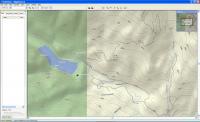
Mapsource software comes standard with (1:100,000 detail for West US, East US, Alaska and Hawaii): I bought the standard Mapsource software and installed it on my pc. When I run the Mapsource software there is a pull down menu at the top that shows 4 choices (West US, East US, Alaska, Hawaii) as choices. The 100K level of detail is not much good on a handheld GPS since the screen is so small....so I purchased the Mapsource TOPO U.S. 24K Southwest DVD (slightly over $100) to provide the 24K detail (for the Southwest US states).

It is confusing the way Garmin packages the Mapsource software. When I installed the Mapsource TOPO 24K Southwest software it just interfaces with the original Mapsource (100K) install (ie. there is not another separate software product on your computer)....so when you run the Mapsource software, the pull down menu at the top, the original 4 items show up (West US, East US, Alaska, Hawaii) ....but now there is also a menu choice for "Topo US 24k. Southwest". If you do the selection properly you can create basemaps for an entire state....or a number of states. I was originally going to make a basemap for each state...but that would require a separate chip for each state (per gps unit) ....so I made a mapset for 4 states and downloaded it in one chip. Warning....if you are making a mapset for several states....it takes a long time. The software just sits there crunching for hours...but it will eventually create the mapset you want. You can then copy the mapset to any number of chips. Be sure to save off the huge mapset you just created for future use so you don't have to ever create it again.

National Geographip Topo:
I love this software for producing top quality USGS topo maps in 24k scale. I print them on Adventure Paper: http://www.amazon.co...r/dp/B00005OMZ9 to produce waterproof quality maps. This is not really paper...but a plastic material that is unbelievably durable (you can print on both sides). The quality of these maps are better than original USGS 24K topo maps. This software is purchased for each state you wish to roam for about $49 per state.

You may not wish to buy that much software....it all depends on what level of detail you need or want. I love having the 24k mapset loaded onto my GPS units AND having the detailed 24K USGS Topo maps to navigate with. Sorry this reply is somewhat long winded but it is a difficult topic to cover with just a few sentences. This may be more information than you wanted.
  • 0

2010 Ford F250 4X4; 6.4 Powerstroke Diesel; Warn 16.5 winch; Airlift Springs; Transfer Flow 47 gal. fuel tank, BDS 4" lift kit, BDS dual steering stabilizer with upgraded Fox 2.0 shocks, Toyo 35X12.50X18 Open Country M/T tires, Pro Comp wheels;  2008 FWC Hawk Camper;  2000 Toyota Tundra.


#18 SunMan

SunMan

    King Taco

  • Members
  • 2,362 posts
  • LocationOxnard, CA.

Posted 11 February 2011 - 10:51 PM

RJones/Leadsled,
Thank you. This is EXACTLY the type of info i am looking for, not long winded at all. I can see how this could get expensive real quick.

A couple more questions, do the TOPO's strictly show hiking trails or do they also include backroads or will i need two different types of software for roads AND trails? I plan to use the device for both hiking/backpacking and driving offroad.

Thanks, and happy to hear feedback from others as well.


  • 0

Sunman
2003 Four Wheel Camper -Hawk

2023 All Terrain Camper - Panther 
2006 Toyota Tundra Double Cab Limited 4WD
2017 Toyota Tundra Double Cab Limited 4WD


#19 RJones

RJones

    Senior Member

  • Members
  • 237 posts
  • LocationMtns of Colorado

Posted 11 February 2011 - 11:34 PM

Here is an example from the Garmin Topo maps. Hiking trails are indicated in dark gray dotted lines. It can be expensive but it depends on what you are trying to accomplish like Leadsled states.


RJones/Leadsled,
Thank you. This is EXACTLY the type of info i am looking for, not long winded at all. I can see how this could get expensive real quick.

A couple more questions, do the TOPO's strictly show hiking trails or do they also include backroads or will i need two different types of software for roads AND trails? I plan to use the device for both hiking/backpacking and driving offroad.

Thanks, and happy to hear feedback from others as well.


Attached Thumbnails

  • Sweetwater Lake.JPG

  • 0
RJones

02 Eagle - 07 Tacoma TRD

#20 leadsled9

leadsled9

    Senior Member

  • Members
  • 935 posts
  • LocationLivermore, CA

Posted 12 February 2011 - 12:05 AM

RJones/Leadsled,
Thank you. This is EXACTLY the type of info i am looking for, not long winded at all. I can see how this could get expensive real quick.

A couple more questions, do the TOPO's strictly show hiking trails or do they also include backroads or will i need two different types of software for roads AND trails? I plan to use the device for both hiking/backpacking and driving offroad.


SunMan,

I actually find the software much cheaper than what I used to have to do. I used to have to buy lots of USGS 24k Topo maps before a hunting trip.....and go down to the USGS map store and spending literally hours of time looking for the right quadrangles (and hoping they weren't out of the ones I needed)....and spending lots of money for maps. Then, often on my hunt, I'd find out I needed a few more to cover areas that look good....but I had no map for.

Now, since I have the entire state in 24k topos....it's simply a matter of printing the maps I need during the hunt....no matter where I am. It's great! Plus, during the hunt I'm always creating new waypoints. When I get back to camp I can download the waypoints from the gps to the computer and they show up on the maps. I can also create waypoints on the computer and download them into the gps. Pretty sweet.

While the National Geographic Topo maps show the road names if you drill down far enough (to the 24K level).....I feel that gps for road travel (generally with turn-by-turn directions) and gps for out in the boonies to be two completely different applications. I have the navigation system in my truck and it is great to find addresses.....or towns....etc. using the turn-by-turn directions.

As for road navigation using Nat Geo Topo, I hovered over Phoenix Arizona and drilled down to 24K....and did a screen print and saved it in a word document so you could see what it looks like. The Nat Geo Topo also show trails, jeep trails etc. just like the USGS Topo maps. The Nat Geo Topo application was actually created from real USGS topo maps.....so just like them....the trails that show up will vary depending on what year the USGS acutally did the survey for creating the 24k map. Sometimes trails will show up on Nat Geo Topo and not on the Mapsource software....and sometimes it's the other way around.

When I'm in the boonies with gps for navigation....I use the UTM (Universal Transverse Mercator) grid rather then Lon/Lat. Lon/Lat was really designed for long straight distance travel such as Marine use in a boat. To successfully use lon/lat for land travel you have to carry a plastic lon/lat overlay.

For land, I believe it is much nicer using UTM. You can set your handheld gps for UTM grid on most units. UTM girds are 1000 meters square, and once you get the hang of it (with a little practice) you can pinpoint your location on a topo map within 50 meters or better (sometimes much better).

The software packages allow the user to use what ever grid system desired. Just set up the maps and gps for UTM and you're good to go. Also, make sure you set the gps "datum" to the same "datum" that the map software is using. For example I set my gps unit and the Nat Geo Topo application to use "NAD83/WGS84" and I'm good to go. If you don't set the "datum" to be the same on the gps and map software.....all of your waypoints will be off by a couple of hundred yards or so.

Well, I wasn't able to upload the word file....so if you pm me your email address....I'll send you a copy.
  • 0

2010 Ford F250 4X4; 6.4 Powerstroke Diesel; Warn 16.5 winch; Airlift Springs; Transfer Flow 47 gal. fuel tank, BDS 4" lift kit, BDS dual steering stabilizer with upgraded Fox 2.0 shocks, Toyo 35X12.50X18 Open Country M/T tires, Pro Comp wheels;  2008 FWC Hawk Camper;  2000 Toyota Tundra.


0 user(s) are reading this topic

0 members, 0 guests, 0 anonymous users