....................................... and just now heard the snow plow go by, so I’ll need to go clear the driveway.
You are getting the hang of it Mr. Sage. 

Belay On

Posted 31 December 2020 - 04:36 PM
....................................... and just now heard the snow plow go by, so I’ll need to go clear the driveway.
You are getting the hang of it Mr. Sage.
2003 Ford Ranger FX4 Level II 2013 ATC Bobcat SE "And in the end, it's not the years in your life that count. It's the life in your years."- Abraham Lincoln http://ski3pin.blogspot.com/
Belay On
Posted 31 December 2020 - 04:40 PM
There is nothing like ice. This reminds me of our morning walk about a week ago.
That video is exactly how it is here today. Yup, micro spikes were required on our walk. Lots of surprised looks on driver's faces when suddenly they discovered they were sliding and could not stop.
2003 Ford Ranger FX4 Level II 2013 ATC Bobcat SE "And in the end, it's not the years in your life that count. It's the life in your years."- Abraham Lincoln http://ski3pin.blogspot.com/
Riley's Human

Posted 31 December 2020 - 09:12 PM
Hope I don't get stuck. Time to get Riley outta Sacramento before the fireworks start.
Craig K6JGV_________________________ 2004 2500 CTD 4X4 FWC HAWK 1960 CJ5
Belay On
Posted 02 January 2021 - 08:29 PM
URGENT - WINTER WEATHER MESSAGE
National Weather Service Sacramento CA
300 AM PST Sat Jan 2 2021

...Winter Storm Expected Monday Through Monday Night...

.A winter storm will bring periods of heavy snow and strong wind
across the mountains of western Plumas County and the western
Sierra Nevada Monday through Monday night. The heaviest snow is
expected Monday afternoon and night for elevations above 5500 feet
with light accumulation possible down to 4000 to 4500 feet.
Hazardous mountain travel conditions are anticipated. If traveling
in the mountains, carry chains, extra warm clothing and food, and
be prepared for significant travel delays. Another winter storm
is possible mid-week which could also impact mountain travel.

CAZ068-069-030000-
/O.EXT.KSTO.WS.A.0009.210104T1200Z-210105T1200Z/
Western Plumas County/Lassen Park-
West Slope Northern Sierra Nevada-
300 AM PST Sat Jan 2 2021

...WINTER STORM WATCH NOW IN EFFECT FROM MONDAY MORNING THROUGH
LATE MONDAY NIGHT ABOVE 5500 FEET...

* WHAT...Heavy snow and strong wind possible. Total snow
  accumulations of 6 to 15 inches, with localized amounts up to 2
  feet are possible. Plan on difficult travel conditions. Damage
  to trees and power lines may occur as well.

* WHERE...Western Plumas County including Lassen National Park and
  the west slopes of the Northern Sierra Nevada. This includes
  Interstate 80 over Donner Pass, Highway 50 over Echo Summit, and
  Highway 88 over Carson Pass.

* WHEN...From Monday morning through late Monday night. Heaviest
  snow expected Monday afternoon and evening.

* ADDITIONAL DETAILS...Strong wind combined with heavy snow will
  make for possible white out conditions at times.
2003 Ford Ranger FX4 Level II 2013 ATC Bobcat SE "And in the end, it's not the years in your life that count. It's the life in your years."- Abraham Lincoln http://ski3pin.blogspot.com/
The Weatherman

Posted 07 January 2021 - 02:25 AM
WEATHER CHANNEL SAYS:
"Model Flip-Flopping Is Proof You Shouldn’t Trust Long-Range Snow Forecast Maps"
FWC Hawk (2005) on a Ford F250 Supercab, 6.8L V10 gas (2000)
Belay On
Posted 11 January 2021 - 08:34 PM
A week ago from today we had thunder, lightning, and driving rain.........................felt like a summer thunderstorm going over. We have highs in the 60's forecast coming the end of this week. Is winter gone?
2003 Ford Ranger FX4 Level II 2013 ATC Bobcat SE "And in the end, it's not the years in your life that count. It's the life in your years."- Abraham Lincoln http://ski3pin.blogspot.com/
Free Range Human

Posted 11 January 2021 - 10:08 PM
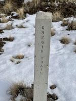
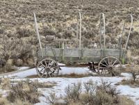
It’s still winter here. The Bride and I walked a portion of the Oregon Trail ruts, near the Oregon Trail Interpretive Center in Baker City. It was below freezing, with 10-15 MPH breeze from the NE. Brrrrrrrr.
I am haunted by waters
Free Range Human
Posted 12 January 2021 - 04:20 PM
URGENT - WINTER WEATHER MESSAGE
National Weather Service Boise ID
315 AM MST Tue Jan 12 2021
IDZ011-ORZ062-122215-
/O.CON.KBOI.WW.Y.0002.210112T1200Z-210113T0600Z/
West Central Mountains-Baker County-
315 AM MST Tue Jan 12 2021 /215 AM PST Tue Jan 12 2021/
...WINTER WEATHER ADVISORY REMAINS IN EFFECT FROM 5 AM MST /4 AM
PST/ EARLY THIS MORNING TO 11 PM MST /10 PM PST/ THIS EVENING...
* WHAT...Snow expected. In the West Central Mountains zone, total
snow accumulations of 3 to 6 inches below 5500 ft, and 6 to 12
inches in the mountains. In the Baker County zone, total snow
accumulations of 1 to 3 inches below 4000 ft, and 3 to 6 inches
below 5000 ft with locally higher amounts up to 18 inches in
the mountains.
* WHERE...In Oregon, Baker County. In Idaho, the West Central
Mountains.
* WHEN...From 5 AM MST /4 AM PST/ to 11 PM MST /10 PM PST/
Tuesday. Heaviest snowfall for the West Central Mountains is
expected to occur after 11 AM MST.
* IMPACTS...Plan on slippery road conditions.
* ADDITIONAL DETAILS...Precipitation will change over to rain
below 6000-7000 ft by Tuesday evening, then change back to snow
above 4000 ft Wednesday afternoon with additional light
precipitation continuing over the West Central Mountains through
Wednesday evening.
PRECAUTIONARY/PREPAREDNESS ACTIONS...
Slow down and use caution while traveling.
The latest road conditions can be obtained by calling 5 1 1.
I am haunted by waters
Belay On
Posted 16 January 2021 - 11:08 PM
66° here currently, an unheard of high temperature for winter................................
2003 Ford Ranger FX4 Level II 2013 ATC Bobcat SE "And in the end, it's not the years in your life that count. It's the life in your years."- Abraham Lincoln http://ski3pin.blogspot.com/
Weekend warrior

Posted 17 January 2021 - 01:23 AM
Transplanted some lettuce starts on a warm January day today. We've been harvesting arugula from under a hoop and visqueen covered garden bed for six weeks now. We NEED rain in Northern California.
2021 RAM 3500 Crew 4x4, 6.4 hemi/8 speed trans with 4.10 gears, Timber Grove bags, Falken Wildpeak 35" tires.
OEV Aluma 6.75 flatbed, Bundutec Odyssey camper on order for 2024
For this year we're still using our 2008 FWC Hawk with victron DC-DC charger, 130w solar, MPPT controler
with 2000w inverter and external 120v output and 12v solar input with 100w portable solar. http://lighthawkphoto.com


0 members, 0 guests, 0 anonymous users

